A FALL AFTERNOON’S HIKE ACROSS THE UP AND DOWN COUNTRY OF
LOWER LITTLE DRY CREEK IN SOUTHWEST NEW MEXICO
Gentle on the Body … Exhilarating for the Soul
SEARCHING FOR OCTOBER GOLD IN SOUTHWEST NEW MEXICO
Setting out from Casitas de Gila Guesthouses for a late October day’s touring and hiking in Southwest New Mexico, the annual Fall foliage of the High Desert landscape presented an ever-changing feast for one’s eyes and soul. On that morning, the air was cool, clear, and crisp, the hard light of the early-morning sun brilliantly illuminating the sinuous band of golden cottonwoods defining the Gila River Valley below as we headed down Hooker Loop. Crossing the Gila, we then headed northwest along Sacaton Road towards our destination: the Mogollon High Country of southern Catron County.
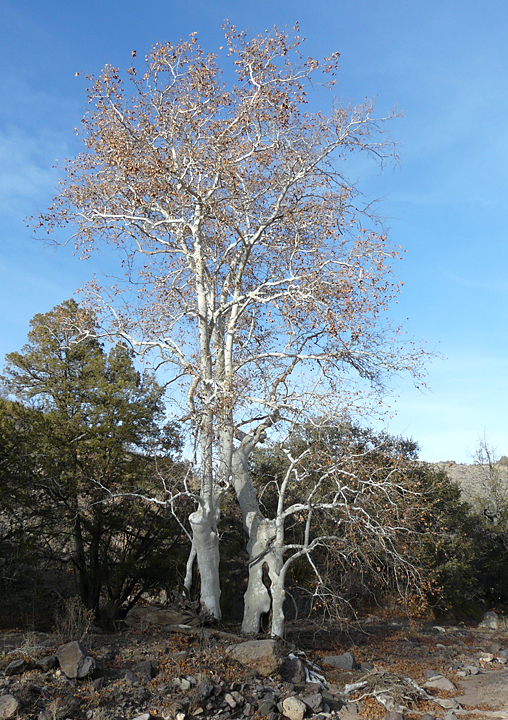

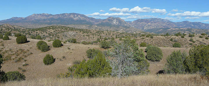
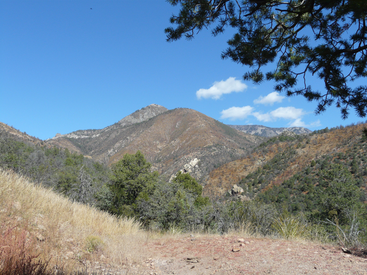
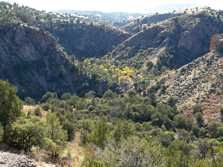
In southern Catron County the highest peaks of the Mogollon Range soar to within an eagle’s cry of 11,000 feet, etching a multicolored tapestry against the late October cobalt sky. Impressive at any time of year, come October, when the Fall colors reach their peak, a cascade of golden yellows and orangish reds slowly descends from the towering groves of Aspen on Whitewater Baldy to the gnarled and ghostly white-trunked sycamores lurking below in the deep canyons of Little Dry Creek.
Our objectives for the day were threefold: 1) check out the condition of Sacaton Road following the mid-September flooding in the western Mogollons; 2) check the status of the Gila National Forest roads leading off from Sacaton Road to the trailheads that provide access into the southwest portion of the Gila Wilderness; and 3) round out the day with an exploratory hike across a portion of the Lower Dry Creek “Mesa” Country lying between the Mogollon Mountains on the east and the San Francisco River on the west.
SACATON ROAD: A SCENIC BACKCOUNTRY ROUTE IN USE SINCE EARLY PIONEER DAYS
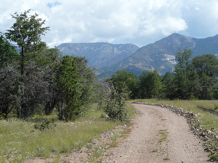
Sacaton Road is a scenic, 25-mile county-maintained gravel road that borders and parallels the northwest trending escarpment of the Mogollon Mountains between Gila and Glenwood. Now little used except for the large ranches it passes through, in the past this road served as a major route of north-south travel and transportation during pioneer settlement of the area. In addition to providing access to some of the best forest trails in the southwest portion of the Gila Wilderness, Sacaton Road offers breathtaking closeup views of the south-facing Mogollon Mountain escarpment that rises abruptly from the valley floor a short distance to the north, as well as expansive views across the gently-sloping grass- and mesquite-covered grazing lands of Sacaton Mesa towards the distant Burro Mountains and the rugged volcanic terrain of the San Francisco River Country.

By 1 PM the first two objectives for the day were completed, with positive results. Thanks to a timely response by Grant and Catron County road departments, Sacaton Road was found to be once more in excellent condition along its entire 25-mile length and ready for all types of vehicular travel. Likewise, the adjoining National Forest roads, trailheads, and trails that lead north from Sacaton Road into the Mogollon Mountains that were visited were found to be in good serviceable condition. While a few of the drainages examined showed some signs of moderate flooding and transported debris, it became obvious that the severe thunderstorms of September 14 and 15 that had caused major flood damage further north in the Whitewater Creek, Silver Creek, and Mineral Creek drainages had not greatly affected the south-facing slopes and drainages in this part of the Mogollons.
As discussed in the September 2013 Nature Blog, this year’s Monsoon Season was long and strong. Most local areas around the Casitas received over 10 inches of rain during the 2-1/2 month period, but it was in the western end of the Mogollon High Country that the totals were the greatest and the thunderstorms most severe. Here, in the headwaters of Whitewater, Silver, and Mineral Creeks, stationary coalescing thunderstorms dropped over 10 inches of rain in a 10-hour period commencing around 5 PM on the evening of September 14 and continuing until around 3 AM the next morning, resulting in devastating floods that severely damaged roads, buildings, and trails in those drainages. Hardest hit were the old mining town of Mogollon on Silver Creek, where the road through the center of town was completely washed away, and the Catwalk Recreation Area on Whitewater Creek, where the elevated metal catwalk and picnic areas were washed away, and the small community of Alma, where the access road to the Mineral Creek trailhead was washed away. As of this date, the Bursum Road (State Rt 159) to Mogollon, the Catwalk Recreation Area, and the access road to Mineral Creek remain closed as repair work continues.
MESAS AND PIEDMONT SLOPE SURFACES
Throughout the Southwest U.S. the term mesa is frequently encountered in geographic place names. Technically, the term is used to describe elevated landforms that have been left behind following a long period of weathering and erosion of horizontally layered rocks of different chemical and physical stabilities. These landforms have the distinctive shape of a flat-topped hill or mountain that are capped with a resistant rock layer, such as a sandstone or a volcanic basalt lava flow, that overlies and protects a weaker and more-easily weathered and eroded underlying layer, such as a shale or ash fall.
Here, in the area surrounding Casitas de Gila Guesthouses in Grant and Catron Counties, there are numerous landforms which have been given local place names that include the term mesa, examples being Circle Mesa between Silver City and Gila, Sacaton Mesa between Gila and Pleasanton, and Whitewater Mesa between Glenwood and Alma. While it is true that these areas display elevated and nearly horizontal layers that rise above the surrounding landscape, they are technically not mesas but another type of arid region landform that would be classified as piedmont slope surfaces.
Piedmont slope surfaces surround uplifted mountain areas and are composed of sediment material eroded from the mountains and carried downslope by running water and gravity out onto the adjacent valley floor where they are subsequently deposited. Over time these processes will build up thick sequences of boulder- to clay-sized sedimentary layers which slope away from the mountain at angles of 2° to 15° towards the valley below, with coarser materials deposited closest to the mountains and grading finer and finer outward and down slope from the mountain source. Piedmont slope deposits are divided into several different types, such as alluvial fans and bajadas, depending on their morphology and relative age.
In the Southwest U.S. many mountain ranges are commonly bordered by high-angle, normal dip-slip faults which separate the uplifted mountains from the downthrown valley floor. Repeated periods of active movement on these faults, plus variation in rainfall due to climate change through time, will result in periodic pulses of greater volumes of sediment being transported out from the mountain escarpment. Once mountain building within an area terminates and these faults are no longer active, the faults are then buried beneath the continuing downslope deposition of sediment eroded from the mountains.
Both the southern escarpment of the Mogollon Mountains along Sacaton Road and the western escarpment of the Mogollons that parallels US Rt. 180 from Little Dry Creek north to Alma are bordered by long-inactive, high-angle, normal dip-slip faults as described in the preceding paragraph. Today these faults are now mostly deeply buried beneath thick deposits of piedmont slope sediment which was carried downslope from the mountains for the last million years or so since the mountain building terminated. In more recent times the topography of these piedmont slope surfaces has been, and continues to be, modified by subsequent erosion and deposition to form the highly dissected and topographically chaotic up-and-down land surface observed today as one travels north from Little Dry Creek on U.S. Rt. 180 north to Alma, especially in the area lying between Little Dry Creek and Glenwood, where the most rugged and highly dissected portions of the piedmont slope surface occur.
LOWER LITTLE DRY CREEK UP AND DOWN COUNTRY: CROSSROADS OF HISTORY
Situated about five miles south of the town of Glenwood, and a half-mile south of where Sacaton Road junctions with U.S Rt. 180 at Little Dry Creek, is the Leopold Vista Overlook, a scenic highway rest stop providing shaded picnic tables and restrooms a few hundred feet west of U.S. Rt. 180. The rest stop is named for Aldo Leopold, a former supervisor with the U.S. Forest Service whose dedicated work led to the establishment of the Gila Wilderness in 1924, the first wilderness area in the National Forest System. Leopold Vista offers the traveling public a breathtaking view of the western end of the Gila Wilderness and the southwest corner of the highest peaks of the Mogollon Mountains. It is a quiet place where the frenetic pace of the open road immediately disappears and the silent magnificence of the natural world once more reigns supreme.
Many hundreds of people, both tourists and locals alike, will stop at the Leopold Vista and marvel at the magnificent view each year. Yet few will notice, let alone take the time to explore and experience, the incredibly complex up and down landscape of alternating flat-topped ridges, arroyos, and canyons that comprise the Lower Little Dry Creek Country surrounding them on all sides, so commanding is the magnificence of the towering Mogollons a few miles to the east.
North-south travel through the jumble of up and down landscape of Lower Little Dry Creek Country has been a challenge to humans since earliest times. Even today there is no straight and easy way across, as evidenced by the winding course and numerous grades encountered when driving through this area following the current route of U.S. Rt. 180. Nearly 500 years ago, in the Summer of 1540, the Spanish explorer Coronado passed through here, probably within less than a mile of the Leopold Vista rest stop, with his expeditionary force of 250 horsemen, 70 Spanish foot soldiers, 300 native Mexican allies, plus over a 1,000 Indian servants, 4 Franciscan monks, and several slaves, before making camp on Big Dry Creek two miles to the north. In a document written some 20 years after the Expedition, Juan Jaramillo, a member of the Expedition, recalled the difficulty of traversing this area, calling this segment of Coronado’s route “La Tierra Doblada”, meaning the up and down or doubled-over country. Three hundred and forty-five years later, on the morning of December 19,1885, it was this same doubled-over landscape that provided the Chokonan Apache Chief Ulzana and his nine warriors the perfect strategic site for the ambush of the 34-man-strong C Troop of the 8th US Calvary under the command of Lt. Samuel W. Fountain while on patrol in the Mogollon Mountains. The ambush took place as the patrol neared the top of a small promontory, known forever after as Soldier Hill, located on the north side of Little Dry Creek, about three-quarters of a mile due north of the Leopold Vista rest area.
THE LEOPOLD VISTA HIKE ACROSS THE LOWER LITTLE DRY CREEK UP AND DOWN COUNTRY
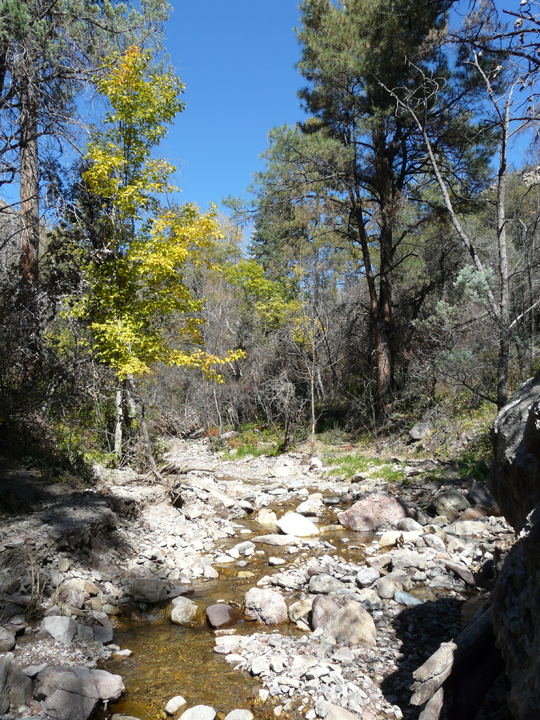
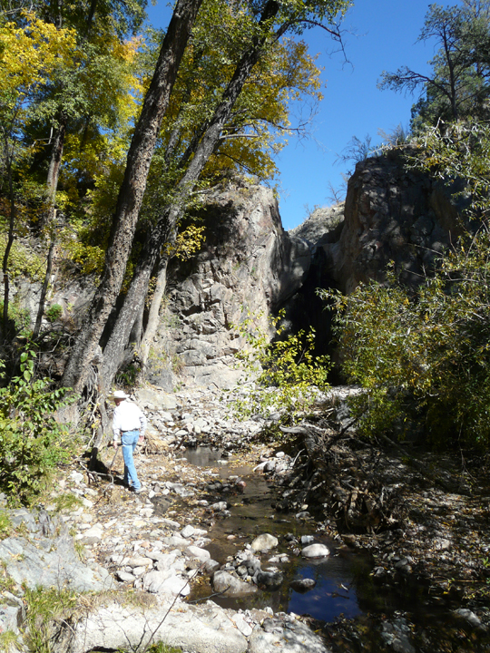
The Casita Nature Blog of April 2013 described a deep, steep-walled canyon hike that offers a fascinating, intimate exploration of the volcanic rocks and flora that line the deeply incised canyons of Little Dry Creek Canyon and its tributaries down to its confluence with Lower Big Dry Creek Canyon, which in turn can be followed downstream to its confluence with the San Francisco River. This hike offers great insight into the geology that borders and underlies the western extent of the piedmont slope deposits that extend westward from the Mogollon escarpment, but affords no opportunity for long view vistas or surface examination of the adjacent up and down piedmont slope geology or ecosystems that border these deep canyons.
Fortunately, for those who would like to experience and better understand the detailed nature of the Lower Little Dry Creek Up and Down Country while surrounded by magnificent views, the Leopold Vista Trail is a National Forest trail that is easily accessed and traversed, just waiting for those who would like to spend a couple of hours or longer hiking in this unusual high desert landscape.
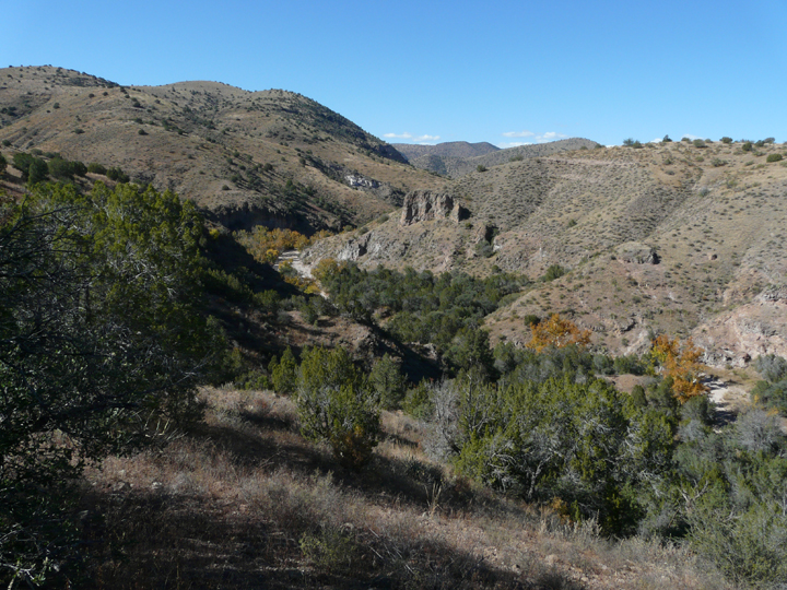
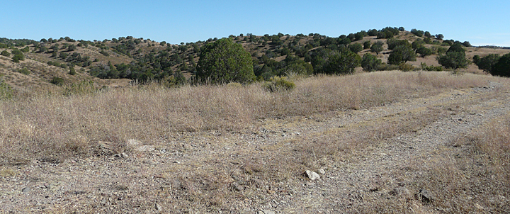
The Leopold Vista trail follows an old four-wheel-drive track across an undulating piedmont slope surface that extends westward from U.S. Rt. 180 for about two miles on the south side of Little Dry Creek Canyon. At several points, less-used tracks split off from the main track which offer views as well as occasional unmarked access down into Lower Little Dry Creek Canyon and several of its side canyons. Incredible long-view vistas extend out in all directions along every part of this hike, affording exceptional opportunities for photography, particularly in the late afternoon. Dominant vegetation along the trail consists of abundant, widely-spaced One-Seed Juniper (Juniperus monosperma), several species of grass including Side-oats Gramma (Bouteloua curtipendula), Desert Scrub Oak (Quercus turbinella), Banana Yucca (Yucca bacatta), Honey Mesquite (Prosopis glandulosa), Catclaw or Wait-a-Minute Bush (Mimosa aculeaticarpa) and occasional Pinyon (Pinus edulis), and Alligator Juniper (Juniperus deppeana). The overall mood of this hike is perhaps best described as one of endless openness and serene expansiveness … and, perhaps, welcoming isolation; a totally different feeling than that felt when hiking within the high-walled confines of the Little Dry Creek Canyon 200 feet below.
The Leopold Vista Trail ends on a narrow finger of a ridge overlooking and 250 feet above the junction of Little Dry Creek Canyon and its tributary Eliot Canyon that comes in from the south. Here, beneath the welcome shade of a juniper, is a great place to rest and have lunch. It is a great observation spot to look for birds and game while scanning canyon bottoms below that stretch off to the west and south and the mountains beyond. Or perhaps to contemplate the possibility that Eliot Canyon was indeed the escape route taken by Ulzana and his warriors following the ambush on Soldier Hill.
Essentially, the two-mile-long Leopold Vista Trail is a scenic, relaxing, easy hike suitable for all ages and physical abilities. However, it can also serve as a starting point for a more strenuous hike down Little Dry Creek and Big Dry Creek canyons to the San Francisco River, or an even more strenuous 1,300 foot climb to the top of Outlaw Mountain.
For the experienced and physically adept hiker armed with relevant 1:24,000 topographic maps, a compass, or preferably a good hand-held GPS, unlimited, off-trail, cross-country hiking and orienteering on Gila National Forest Land is possible to the north and west from several points along the Leopold Vista trail. Perhaps it is only by taking a cross-country hike to the north on a course that requires crossing several of the east to west drainages and intervening ridges and flats on the piedmont slope surface that one could gain a full appreciation of the challenges those early travelers, such as Coronado, calvary on patrol, or miners chasing the promise of gold and silver riches in early Mogollon, faced in traversing the Up and Down Country of Lower Little Dry Creek.
Yes, history abounds in the up and down country of Lower Little Dry Creek, both geologic and cultural.
NOTE: While at first consideration this is an easy hike that traverses a nearly level landscape, it passes over very open terrain with little shade. Ample water, sunscreen, long sleeves and pants, and a wide-brimmed hat should be considered essential. Early morning or late afternoon would offer the best times for hiking, and Fall through Spring the best seasons. As always Casitas de Gila Guesthouses is happy to provide to our guests up-to-date conditions, directions, and maps for any of the hikes in the area.
