casitas de gila guesthouses bed and breakfast new mexico 575-535-4455
info@casitasdegila.com

Southwestern Guesthouses on 265 Acres
near Silver City, New Mexico
overlooking Bear Creek and the Gila Wilderness

Casitas de Gila Nature Blog

Casitas de Gila Nature Blog

November Birding in SW New Mexico

We would like to thank Ed and Betty of Columbia, Missouri. They were guests here at Casitas de Gila Guesthouses in November 2019. They had such a wonderful time birding here, that they left this amazing story in our Casita guestbook. It’s so wonderful, we just have to share it!

——————————————————————————–

Our deep thanks to Becky & Michael for their long labor of love shepherding this place. We benefited immensely.

We arrived when a bitter arctic air mass (in Nov!) swept through the eastern states. Our town, Columbia, MO, had a record low of 9°F / snow. It was a chilly morning here. I put a “bird bath” out on the outside table and it froze solid 2 mornings. Interestingly, there wasn’t much frost on the car, though; too dry I suppose. So the mornings and evenings were just right for a comfortable cedar wood fire inside. But the afternoon temps climbed to the 60s each day! And the skies were wonderfully clear and blue. Absolutely still in the mornings, with the (modest) breeze gathering in the afternoon.

Woodhouse's Scrub Jay

Woodhouse’s Scrub Jay

I brought 10 lbs of birdseed (to add to the Casitas’ store) and enjoyed the morning and evening parade. A few were familiar from back home: the cardinal, white-crowned sparrow, and junco (although the Oregon color phase was present here). The bluejay of Missouri was replaced here by the SCRUB JAY, just as beautiful in its own way. At first I thought it was timid … turns out these jays get real used to you! Our secretive brown thrasher was replaced here by the (also secretive) CURVE-BILLED THRASHER. Indeed, that impressive beak is curved like a scimitar. And that reality is not lost on the other birds … this thrasher ruled the feeding dish. Even the scrub jay, slightly larger, moves right out of the way when the yellow eyes show up, scurrying out from under the juniper.

Curve-Bill Thrasher

Curve-Bill Thrasher aka “Yellow Eyes”

Another cousin-bird here was the juniper titmouse, standing in for our more familiar tufted titmouse. It’s smaller and “gray-browner” but very much a titmouse in its behavior.

Spotted Towhee

Spotted Towhee

The handsome SPOTTED TOWHEE splashed in a couple of times. Beautiful, quick, wary bird – much like the mourning dove back East.

Finally, at least as well as last, was the BUSHTIT. There’s really no parallel to those tiny birds back home. Diminutive! Just ½ as big as a Carolina chickadee. They buzzed in like 6-8 bees, then away.

These wonderful birds graced our feeding station. But there were birds we saw that were part of the larger landscape. And the one who lives on the largest scale is the raven. The (common) raven owns this country. They see everything for miles from their high mt. Lairs, or from the sky, which they can “row across” in a hurry. Their amazing voice announces them, high overhead, sailing up Bear Creek, or echoing from the surrounding peaks.

Bushtits on Suet Feeder

Bushtits

Robin

Robin


On a lesser scale, but still leading a landscape-wide life, were the ROBINS. From afar they zoom in, dropping into the tall trees lining Bear Creek, perhaps after hackberry fruit, perhaps ready for a drink and a splash. I suspect they help themselves to the juicy fruit of the one-seed juniper, of which there must be about a trillion in this state. Yes, juicy! The Eastern red cedar we encounter in Missouri makes a lot of fruit (not technically berries, but botanically a modified cone), but their (smaller) fruit is mealy and dry. I didn’t see robins eating the strangely juice cones, but I suspect it. And I did see their cousins the western bluebirds eating them.

Gambels Quail

Gambels Quail

We walked up the drive (“Courage”) and up the Double E Ranch Road and saw about 40 of these wonderful bluebirds, clustered in just one juniper …one tree. Out of a trillion … gorging themselves on juicy fruit. Then on the way back, the GAMBELS QUAIL were there. Some tree. They panicked out of there, running across the road in front of us. So why that one tree? I looked it over. Loaded with fruit, but so are all the other female junipers — for miles around. A mystery. But it was a very orderly panic. These collegial birds run in single file, always. And there are other single-file creatures on that road. A group of 9 winter-gray mule deer bounded across as well. Single file, and “pronking” to demonstrate just how foolish we would be to chase them. Actually, we’re not that foolish, but it was fun to see them pronk.

The red-tailed hawk we saw sitting solemnly on a telephone pole was just the opposite of the exuberant deer. He didn’t even twitch as we went by, positive that the pole was erected for him and him alone. But the bird seemed quite large — probably a female.

Acorn Woodpecker

Acorn Woodpecker

A couple of other landscape-wide birds were woodpeckers. The northern flicker flies from place to place out here. The big white blotch above the tail really shows in a land of gray trees. But where was the mustache? I’m color-blind, so couldn’t see the red malar on these western birds. And another special sighting was the ACORN WOODPECKER. They’ve a black and white cousin back east as well, the red-headed woodpecker. A fast flyer, this acorn-eating hoarder flashed across the sky ahead of us like a comet!

Then there were some particular birds. That is, because they’re particular about where they live; only in certain habitats. The hairy woodpecker we saw down on the large cottonwoods lining Bear Creek. The mallards we saw having a float down the Gila River. And the CRANES! We saw them from the bridge in the tall grass by the Gila River. It was a group of four. Earlier in the day I heard their wild raucous trumpeting fro the top of the Hooker Loop. That’s ~3 miles away. Their calls carried perfectly in the still morning air.

Sandhill Cranes

Sandhill Cranes

Finally, my last bird. This one I saw down in the creek bottom. I heard a loud scolding, then to my surprise there were two “furious” little wrens. Very bright little birds, marvelous marsh wrens. I had never seen one before. It was a real gift. They were frequenting the seep willow thicket, a perfect place for a marsh-loving bird.

Wild Turkey

Wild Turkey

Of course there were other evidences of birds and animals. I hiked up the Double E Ranch trail [what we call the Casitas’ Paradise Overlook trail] to the top of a little mountain. Wild turkeys had preceded me, their droppings in abundance proving it. And I should mention the cliff chipmunks. They frequent the bird feeding station as much as any of the birds, waving their plumy tails if a bird approaches too close. They like to scatter the juncos and even stand their ground (in the feed dish) against the scrub jays! However, they yield to the yellow-eyes.

So there’s lots more, but I’ve burned up too many pages and I’m done. Thank you again, Becky and Michael. We hope to see you again.

Cliff Chipmunk

Cliff Chipmunk

Bird feeding station

One of our new bird feeding stations


Posted in birdwatching | Tagged , , | Comments Off on November Birding in SW New Mexico

Spring Birding and Migration

WITH SPRING, THE BIRDS THEY ARE A-CHANGING
AND SPRINGTIME MEANS NESTING TIME
AT CASITAS DE GILA GUESTHOUSES


zone-tailed hawk and nest

Zone-tailed Hawk and nest

SPRING HAS SPRUNG AND THE SIGNS ARE EVERYWHERE

Over the past week, it was obvious that the Seasons have cycled once more. Looking down into Bear Creek Canyon from the porch of the Casitas both the Freemont Cottonwoods and the Bluestem Willows have awakened, their green and yellow catkins glistening in the bright morning sun, now all abuzz with bees and other insects.

budding cottonwoods on Bear Creek

Budding Cottonwoods on Bear Creek

bluestem willow catkins

Bluestem Willow Catkins


As anticipated in February’s blog, the above-average late Winter snow and rain have indeed brought out an abundance of numerous species of early February and March wildflowers, and now April wildflowers blanket the ground around the Casitas.

Gordon's Bladderwort

Gordon’s Bladderwort along Casita Flats Road


Stemless Evening Primrose

Stemless Evening Primrose in bloom

golden smoke flower

Close-up of Golden Smoke flower


It is afternoon and while hiking down along Bear Creek, one comes upon one of the Casitas’ almost-year-round residents, just returned from its unknown Winter getaway: a Great Blue Heron, standing motionless in the Creek. Sensing one’s presence, the heron quickly snatches a minnow at its feet, and then silently rises, gliding away upstream.

Canyon Tree Frog

Later, shortly after dark, one goes outside and hears again a sound that just two nights ago greeted one’s ears for the first time this year. It is a delightful yet primeval sound, one that over the years has proven to be the most definitive and reliable proof of Spring’s arrival here at the Casitas: the joyful chorus of a multitude of Canyon Tree Frogs passionately engaged in a performance of their annual Spring mating call concert, a performance that one knows will be repeated in early July with the onset of the Monsoon Season.

sandhill cranes

Sandhill Cranes

black-chinned hummingbird

Black-Chinned Hummingbird


Over the past two weeks the bird populations here at Casitas de Gila, the Bear Creek Nature Preserve, and the nearby Gila River have also undergone dramatic change. Many of the Winter birds, from the stoic Sand Hill Cranes to the flocks of gregarious Dark-eyed Juncos, have either left the area or are in the process of leaving. While at the same time our regular Spring and Summer birds, from soaring Common Blackhawks and Turkey Vultures to darting Black-chinned Hummingbirds and Violet-green Swallows, to night-time murmuring Common Poorwills, are arriving daily. For Casitas de Gila’s birding guests, Spring migration is showtime! Just this week, while visiting one of the eight dedicated public birding sites along the Gila River, just a few miles from the Casitas, four of our guests enjoyed seeing two magnificent male and one female Vermillion Flycatchers!

Vermillion Flycatcher

Vermillion Flycatcher


A SPECIAL TREAT FOR CASITA DE GILA BIRDING GUESTS DURING SPRING 2019:
NESTING ZONE-TAILED HAWKS IN THE BEAR CREEK NATURE PRESERVE

zone-tailed hawk

Zone-tailed Hawk

To the delight of our birding guests, during the past week a mating pair of Zone-tailed Hawks have been building a very large nest in the top of the large, ancient Arizona Sycamore that grows up against the high cliffs of Gila Conglomerate on the other side of Bear Creek, directly across from, and in unobstructed view of, the Casitas. It was a special treat for a few days as our guests watched through their spotting scope as the two birds selected dead branches for their nest from shrubs on the adjacent cliffs during the morning and afternoon. Over the coming weeks these nesting hawks should provide lots of on-going entertainment for incoming birding guests.

Welcome Lady Spring! Welcome!


Posted in birdwatching, nature, spring, wildflowers | Tagged , , | Comments Off on Spring Birding and Migration

Spring Wildflowers

2018-19 WINTER MOISTURE SUGGESTS
AN ABUNDANCE OF SPRING WILDFLOWERS
At Casitas de Gila Guesthouses in Southwest New Mexico


Will Casitas de Gila Guesthouses see a Return of the
Elusive-Yet-Magnificent Doubting Mariposa Lily?


Doubting Mariposa Lily

The Magnificent Doubting Mariposa Lily — last seen in 2015

Typically, Spring wildflowers at Casitas de Gila Guesthouses begin to appear in protected sunny areas during the last half of February, with a peak in late March or April, and a decrease in May with the onset of the dry season. Species diversity and relative abundance of Spring flowering plants in Southwest New Mexico are primarily controlled by the amount of precipitation and average temperature during December, January, and February. As explained in the Casita Nature Blog of January 2015, these factors are strongly controlled by the cyclical pattern of the warm versus cool phases of equatorial surface waters in the Pacific Ocean, known as El Niño Southern Oscillation (ENSO), where the warm phase, El Niño, results in warmer temperatures and more precipitation, and the cool phase, La Niña, results in cooler temperatures and less precipitation.

During the Winter of 2014-15, Southwestern New Mexico was experiencing a weak El Niño phase with an exceptional and well-above-average amount of precipitation in the form of both snow and rain. During December 2014 and January and February 2015, Casitas de Gila received a total of 3.72 inches of precipitation (which included the exceptional seven-inch snowstorm of January 2, 2015). As a result, with the coming of Spring in 2015, guests at the Casitas were treated to an amazing extravagance and profusion of common, as well as rarely seen, wildflowers, such as the magnificent Doubting Mariposa Lily that emerged between early March and late May. This spectacular flowering of Spring 2015 had not been witnessed in the 14 years of previous operation of the Casitas de Gila. Nor has it been repeated since. The flowering was so spectacular that two separate blogs were written at the time to celebrate the event. Readers of this blog will find most of these flowers identified, discussed, and profusely photographed in the March 2015 and April 2015 blogs.


WILDFLOWER PROGNOSIS FOR 2019 AT CASITAS DE GILA GUESTHOUSES

It is with this background, then, that we can turn to the prognosis for wildflowers for Spring 2019. Climatic factors prevailing during the Winter months of 2018-19 continue to closely match the climatic factor experienced during the same period of 2014-15.


Primary Climatic Factors Affecting 
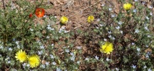
Spring Wildflowers in Southwest New Mexico

Precipitation

Total precipitation at Casitas de Gila so far this Winter (December 2018 thru February 23, 2019), which includes an 8-inch snowstorm on December 28 and a 5-inch snowfall on January 1 and 2, totals 3.42 inches, comparing closely to the 3.72 inches received for the same period in 2015.

El Niño Southern Oscillation

In addition to the precipitation similarities, other regional climate factors for December, January, and February for 2014-15 and 2018-19 are also very similar, such as the phase of the El Niño Southern Oscillation (ENSO). The ENSO, as recorded on the National Oceanic and Atmospheric Administration’s Oceanic Niño Index (ONI), for both time periods shows the presence of a weak El Niño phase which favors more moisture in the Southwest during the Winter months.

Jet Stream Patterns

Integrally related to the ENSO phase for any given year in the Southwest are the prevailing atmospheric patterns of the Jet Streams. The El Niño Southern Oscillation (ENSO), manifests as irregular variations in winds and sea surface temperatures over the tropical equatorial eastern Pacific Ocean. These varying winds and temperatures, in turn, interact with and affect the major currents of air encircling the Earth in the Northern Hemisphere known as the Jet Stream. The Jet Stream consists of two distinct, rapidly-moving masses of air that encircle the Earth in both the Northern and Southern Hemispheres at elevations of 30,000 to 50,000 feet. In each hemisphere there is both a Polar Jet and a Sub-Tropical Jet. These two currents of air vary in position and pattern along with the seasons, and in the Northern Hemisphere are closely tied to the ENSO phenomena, as shown below from the National Oceanic and Atmospheric Administration.

typical Jan-Mar weather anomalies

This image shows the pattern that is normally experienced in the Southwest for El Niño jet streams during January-March. However, in recent years the Southwest has repeatedly experienced a much different, anomalous pattern which is well illustrated by the Winters of 2014-15 and 2018-19. In this anomalous pattern, the Polar Jet Stream repeatedly dips down from the Arctic in a southward loop along the West Coast of the United States, dragging with it embedded, moisture laden, low pressure systems which intersect and combine with the eastward moisture laden flow of the Pacific Jet Stream, resulting in above-average rain and snowfall to the Southwest. This recurrent jet stream pattern is illustrated below in three Archived Jet Stream Maps as produced by the Department of Earth and Climate Sciences at San Francisco State University. As can be seen in these maps, the Jet Stream pattern in the Southwest for the Winter of 2018-19. continues to be virtually the same as that of 2014-15.

jet stream map for February 26, 2015

Jet Stream Map for February 26, 2015

jet stream map for 12/28/18

Jet Stream Map for December 2, 2018; Casitas de Gila received 8 inches of snow (approximately 0.8 inches rain)

jet stream map for 2/5/19

Jet Stream Map for February 5, 2019; Casitas de Gila received 0.32 inches rain

Effect of Cloud Cover Upon Ground Moisture Retention

A final climatic factor which greatly affects the abundance of Spring Wildflowers in the Southwest is the amount of cloud cover during the December–March Winter season. As discussed above, La Niña years are dry and cold in the Southwest. But in stark comparison to more cloudy El Niño years, La Niña years are also characterized by endless cloudless days of crystal clear, cobalt blue skies, illuminated by an incredibly brilliant Southwest Sun. As would be expected, all of these sunny days quickly evaporate most of the scant moisture that might fall during the La Niña Winter months, but are also very effective at drawing out moisture retained in the soil left over from the previous Summer monsoon and rainfall during the Fall. Thus, La Niña years typically have a much lower ground moisture content going into Spring than the wetter and cloudier El Niño years, which leads to a much reduced showing of both numbers and species of wildflowers.

Days of increased cloud cover always accompany the arrival of moisture-bearing low pressure weather systems. Thus, greater precipitation, cloud cover, and consequently increased ground moisture retention, are to be expected during Winter seasons such as 2014-15 and 2018-19 where the Polar Jet Stream with embedded low pressure systems repeatedly drop down into the Southwest to merge with the moisture laden Pacific Jet Stream.


AND THE WILDFLOWER PROGNOSIS FOR 2019 IS . . .

In this Blog both the 2014-15 and 2018-19 Winter seasons have been shown to be extremely similar with regards to all of the climatic factors, which would favor a Spring wildflower showing of exceptional abundance and diversity. Assuming that there are no great changes in the climatic factors during the coming month, guests at Casitas de Gila during March through May are highly likely to witness a bountiful repeat of the exceptional 2015 Spring Wildflower florescence!


Posted in spring, wildflowers, winter | Tagged , | Comments Off on Spring Wildflowers

The Cliffside Loop Trail

EXPERIENCING THE INEFFABLE ON THE CLIFFSIDE LOOP TRAIL
A Special Place of Nature within the Casitas de Gila Bear Creek Nature Preserve

view of Gila Wilderness

Situated in a Special Place on the west side of Bear Creek Canyon, Casitas de Gila Guesthouses provide a timeless view of the Gila Wilderness and Turtle Rock

SPECIAL PLACES IN NATURE

Within every Natural landscape there are places that are so special that they are capable of creating a deep state of awareness, well being, or sometimes even transcendence, upon those who visit. Such places can range in scale from the grandiose, as in our National Parks, where visitors are typically awestruck by the magnificence of Nature before them. Or, they can be much smaller, often hidden, little places … places that are quickly passed through, completely unnoticed by the hurrying hiker, yet equally capable of instilling the same degree of an ineffable sense of well being to those who would stop and linger. Many of these special places in Nature possess an enchantment that is timeless, enduring for thousands of years. More typically, however, that specialness is much more ephemeral, sometimes lasting only a few moments at a certain time of day, perhaps sensed only during a certain season, or possibly lasting a few years before that elusive essence is gone.
 

CASITAS DE GILA GUESTHOUSES – THE VISION BECOMES REALITY

fall foliage near Silver City

A Special Place within the Bear Creek Nature Preserve for just a few moments in time at Casitas de Gila

It was very late on a crystal clear afternoon in October of 1998, when we first viewed the magnificent landscape surrounding what would eventually become Casitas de Gila Guesthouses. Behind us, the setting Sun was already starting what we would soon come to call “the Magic Hour”: our daily yellow, to orange, to red, magic light show on the distant mountain ramparts of the Gila Wilderness to the north, the closer towering crags of Turtle Rock and the two smaller mountain peaks rising up from the east side of Bear Creek directly in front of the Casitas. Instantly, without speaking, we each knew that this was it: this was the Special Place in Nature that we had long envisioned and had been searching for. It was an emotional moment for both of us. We were home.

From that moment almost 19 years ago, both we and our guests at Casitas de Gila have been privileged to enjoy this incredible New Mexican landscape that surrounds us, a unique landscape of mountains, rock, and sky, that changes dramatically in response to the daily and monthly cycling of the Sun and Moon, the Seasons, and the ever-changing weather. But while the distant view from the unique cliffside perch of the Casitas was spectacular from the beginning, the view down into Bear Creek canyon was not that special when we first arrived on Bear Creek.

winter snow in the Gila

Bear Creek and Turtle Rock from the Casitas, March 5, 2015


hiking in the gila wilderness

This is what the entire Bear Creek floodplain in front of the Casitas looked like in October 1999

Of course any year-round running creek in high-desert Southern New Mexico can and should be considered special in its own right. However, in 1999, when looking down into Bear Creek Canyon from the Casitas now under construction, what met the eye was a rather uninspiring, narrow rivulet of water winding its way south down a broad, featureless floodplain strewn with a chaotic jumble of grayish-tan boulders, gravel, and coarse sand, broken only by a scattering of logs and other vegetative debris left over from the last monsoonal flash flood in September. Other than a few old-growth cottonwoods and sycamores along its outer edge, there was not the expected growth of a diverse riverine forest across this floodplain, but only a few clumps of mostly less than head-high, flood-decimated vegetation.

On initial hikes downstream along the Creek one observed that this riverine landscape showed all the signs of a creek and floodplain greatly out of natural equilibrium, apparently the result of an ongoing cycle of repeated major flash floods that had resulted in extensive erosion, scouring, and transitory channels that migrated back and forth across the entire floodplain due to the lack of vegetation. Why were there no actively growing stands of young trees and shrubs here on this floodplain, as commonly found elsewhere in the area? Was the Bear Creek drainage experiencing an unusual period of exceptional rainfall, or perhaps an increase in Summer Monsoon flash floods that had eroded and carried away all the normal floodplain vegetation?
 

THE BEAR CREEK NATURE PRESERVE – BEGINNINGS

It would be a year or two before the answer to that question was fully understood by us, even though the answer was literally wandering around before our eyes from the the first moment we looked down on Bear Creek 80 feet below. The reason was cows, lots of cows, voracious cows, that seemed always hungry and constantly looking to devour any remaining green shoots of grass, weeds, willow, or cottonwood seedlings and just about any other plant that had managed to sprout within the floodplain since the last big flash flood. Gradually, over time, the simple answer became quite obvious: the barren boulder and gravel strewn floodplain in front of the Casitas was simply due to repetitive cycles of overgrazing by legions of voracious cattle following major flash floods!

Construction of the Casitas began in February of 1999. By June two guesthouses were finished, allowing us to move onto the Casita property from the temporary quarters in Gila we had rented while our house and office were being finished. In addition to our dog, Gus, and our cat, Spota, both of which we had brought with us from Ireland, we also moved up our two horses, Saino and Yaqui, which we had acquired locally shortly after our purchase of the Casita property. We built a small corral down at the creek, and fenced off the north and south ends of our property to keep out the cows that had been invading from points upstream so our horses could enjoy the sparse amount of fresh green grass that remained on the floodplain, in addition to their regular rations of alfalfa hay.

With the coming of Spring the following year, after fencing out the cows, we began to notice that that the remaining clumps of vegetation on the floodplain were enlarging. Nature was beginning to put the floodplain back in balance, and our two horses, try though they might, were simply unable to keep up with the massive and rapid growth of the vegetation that was taking place!

During the next two or three years after the Casitas opened, Bear Creek continued to migrate here and there across the floodplain, eventually coming to stabilize in a channel on the east side of the floodplain, at the foot of the mountains across from the Casitas. At the same time, and to our great delight, a scattered but promising stand of young cottonwoods, willows, and sycamores were taking root over the rest of the floodplain, greatly enhancing the view of Bear Creek from the Casitas.

airbnb near silver city new mexico

The Bear Creek Nature Preserve from the Casitas,
July 9, 2001

cabin for rent silver city, new mexico

The Bear Creek Nature Preserve from the Casitas, October 22, 2004


As the vegetation over the flood plain expanded and stabilized, The Casita Loop Trail, a half-mile Self-guided Nature Trail with a comprehensive printed guide, was completed in 2002, so our guests could discover, explore, and learn about the overall Natural History and various natural phenomena that were now taking place along the Creek. Starting and ending in front of the Casitas, the half-mile loop trail was constructed down the Gila Conglomerate cliffs on the west side of the canyon, where it would cross Bear Creek and then meander north upstream for a quarter of a mile through the floodplain forest, before crossing back over Bear Creek and climbing back up the cliffs to the starting point. Thus, what we call the Casitas’ Bear Creek Nature Preserve was born, and what a Special Place it was becoming!

lodging in silver city, new mexico

The Bear Creek Nature Preserve during the Great Flood of February 12, 2005

b&b in silver city, new mexico

Not a good day for relaxing in the hammock along Bear Creek, February 12, 2005


Then, in February 2005, a major three-day storm coming up from Mexico brought about three inches of rain over the entire Gila area, melting most of the Winter snow in the Gila Wilderness and causing major flooding on the Gila River and Bear Creek for almost two weeks. During this time the entire Bear Creek floodplain in front of the Casitas became one vast, 200-300 foot wide raging river, with depths peaking at eight feet above normal. Eventually, the flood waters did finally recede to reveal an unexpected surprise. Hidden beneath the turbulent waters of the flood, Mother Nature had certainly been very busy, for now the main channel of Bear Creek was found to be relocated 200 feet to the west on the Casita side of flood plain, somehow bypassing and leaving the young stand of young riverine forest in the middle of the floodplain essentially intact with little significant damage; a spatial rearrangement of Nature that has persisted up to the present.
 

hiking in the gila wilderness

The Bear Creek Nature Preserve as seen from the Casitas, November 3, 2012

THE BEAR CREEK NATURE PRESERVE – A THRESHHOLD IS REACHED

darkest skies in united states

A threshold is reached in the Bear Creek Nature Preserve, November 1, 2013

Between 2003 and 2010, Casitas de Gila Guesthouses acquired several additional parcels of land, greatly expanding the Bear Creek Nature Preserve from its original 71 acres and one-half mile of Bear Creek to 265 acres and three-quarters of a mile of Bear Creek, with over 5 miles of new trails on the property. During this period of expansion and the following two or three years, out of necessity most of our attention was diverted from our original Bear Creek Nature Preserve to focus on acquiring and then learning about these new lands and habitats to determine how they could best be utilized and preserved for the benefit of both our visiting guests and the diverse variety of fauna and flora that lived there. And during this time, pretty much unnoticed by us, the Bear Creek Nature Preserve matured: the young cottonwood, sycamore, ash, and walnut saplings became big trees, while an understory of highly-diverse species of shrubs, ground cover flora, and grasses spread across the floodplain, reestablishing a dynamic equilibrium with the periodic floods surging downstream.

Thus it was, between 2013 and 2014, that several of our long-term returning guests, some who had been coming for many years, began asking questions like “What’s going on in the floodplain?”, “The floodplain seems so different now; the trees seem to be much bigger”, “It’s getting to be like a jungle down there”, or “There seems to be so much more wildlife now”. And, indeed, they were right! As so often happens in Nature when something is observed only at spaced intervals, great changes had taken place. A Natural Threshold had been reached in the Bear Creek floodplain below the Casitas. Protected from the incursion of the cows and human development, and within a little over a decade, the natural environment of the Bear Creek riverine ecosystem had been restored. Mother Nature, the primal force that never sleeps, had done her thing …
 

hiking in the Gila Wilderness

The Cliffs at the south end of the Bear Creek Nature Preserve

THE CREATION AND DISCOVERY OF A VERY SPECIAL LITTLE PLACE IN NATURE
WITHIN THE BEAR CREEK NATURE PRESERVE

Towards the southern end of the Casitas property are massive, 120-foot high, vertical rock cliffs that form the east border of the Bear Creek floodplain. These cliffs are composed of a rock formation called the Gila Conglomerate which display layers upon layers of well-cemented, horizontally-bedded sedimentary rock comprised of silt, sand, coarse gravel, and large boulders of mostly volcanic material. Millions of years ago, ancient rivers flowing out of nearby volcanic mountains deposited and sequentially buried these layers of sediment. The thick sequence of Gila Conglomerate as seen in the cliffs today are the result of many thousands of years of erosion and downcutting action by Bear Creek.

Prior to the 2005 flood, Bear Creek was flowing up against these cliffs, with the Self-guided Nature Trail located 150 feet to the west, running parallel to Bear Creek and cliffs. Then, during the 2005 flood as described above, Bear Creek relocated to the west side of the Canyon, putting the Nature Trail on the east side of the Creek just west of the cliffs.

stargazing in the gila wilderness

During the flood of 2005, the floodwaters flowed along the base of the cliffs, completely submerging what would become the Cliffside Loop Trail

astronomy in western united states

This photo shows the cliffs immediately downstream from the photo on the left. The photos were taken at the same time; left two-thirds of this photo shows the entire cliff face that would be included in what would become the Cliffside Loop Trail; note the absence of significant vegetation at the base of the cliffs


By Late Summer and Early Fall of 2005, a line of young cottonwood and sycamore shoots could be seen growing between Bear Creek and the Nature Trail to the east. At the same time, a rather continuous line of Bluestem Willow shoots began to grow along the east side of the Nature Trail. Further toward the cliffs, scattered shoots of young cottonwoods, sycamores, and Red Willows were also popping up. Mother Nature was wasting no time in reclaiming and revegetating the floodplain where Bear Creek had been flowing just a few months before.

During the next nine years there were no major floods to change the course of Bear Creek or to disturb the gradually maturing riverine forest across the floodplain. As these years passed, one noticed how the view from the Casitas of the forest across the floodplain below was steadily increasing in grandeur, as the cycling of each season recast the floodplain from a ever-changing palette: from the somber blues, grays, and mauves of Winter, to the delicate yellow-greens of Spring, to the mysterious, deep, forest greens of Summer, to finally climax as a blazing ribbon of gold in the Fall.

blue stem willows new mexico

Trail crossing Bear Creek to the passageway through the Blue Stem Willow thicket

dark skies in western united states

The passageway through the Blue Stem Willow thicket

Trails in the Bear Creek floodplain require maintenance with the tractor at least two and sometimes three times a year. It was during the Summer of 2015, while doing trail maintenance across the Creek in front of the cliffs at one of the stops on the Self-guided Nature Trail, that one noticed how the line of Blue Stem Willows along the east side of the trail had grown into an impenetrable,15-20 foot high thicket that completely blocked the view of cliffs behind them; a view which was the subject of a lengthy discussion at that particular stop in the Nature Trail guide. Upon investigating, it was discovered that the problem might be easily solved by cutting an opening through the thicket into what appeared to be a small natural clearing just on the other side of the thicket.

A narrow passageway, just wide enough for a person to squeeze through, was easily cut through the thicket. Passing through into the clearing one observed that the view once again matched the description in the Nature Trail guide: a spot where great views of the cliffs and the Big Horn Sheep that occasionally came to the cliffs, and the large variety of birds that frequented the area, would once again be available to guests using the Nature Trail guide.

birdwatching in the gila wilderness

The clearing just inside the passageway

Upon entering the clearing for the first time, however, one immediately sensed that there was much more here than just the view of the cliffs. There was also an ineffable feeling of having just discovered of one of Nature’s Special Places, a place that up to that moment had been completely hidden from the world outside by the enclosing willows, young cottonwoods, and sycamores; a newly-created Special Little Place never before witnessed by a human being.

Over the next two years, this Special Little Place became a favorite stop for guests walking the Self-guided Nature Trail, and a favorite haven for those seeking the deep solace and connection that only pristine Nature can provide.

By late 2017, it was obvious that the cumulative effect of the many small, but constantly occurring, natural changes along the Self-guided Nature Trail since the 2005 flood had rendered the existing guide essentially useless. Javelina had eaten several of the cacti referenced in stops on the canyon side, while other referenced plants had simply died during droughty periods and vanished. Down in the floodplain, ground squirrels had taken away the orange tapes marking trail stops, either for making nests or perhaps just out of spite because of some innate, inexplicable dislike for neon orange. Also, with the culminating growth and maturing of the Bear Creek floodplain forest, Mother Nature had accomplished such a complete makeover that many of the stops as described in the guide bore little or no resemblance whatsoever to observed reality. It was time to bite the bullet. A comprehensive rewrite of the Nature Trail guide was long overdue.

hot springs in the gila wilderness

Looking north through the clearings between the cliffs and the trees along Bear Creek

A new field study and evaluation of the entire Nature Trail was needed before the rewriting of the guide could begin. Immediately, it became obvious that this was not going to be an easy task. After a few days work, the field work for the rewrite had progressed to the other side of Bear Creek to the Marked Stop in the Nature Guide for the “Special Little Place” by the cliffs. Stepping through the opening in the willow thicket into the clearing on the other side one realized that this was the first time that one had visited the little clearing in Winter.

With all the leaves off the trees, closer examination of the clearing revealed that what up to that time had been considered a rather small clearing enclosed by dense vegetation was actually a series of elongated clearings that extended a couple of hundred feet to the south between the cliffs and Bear Creek before ending where the channel of the Creek shifted against the cliffs. Dense stands of young cottonwood, sycamore, and willow lined the west side of these clearings along the creek bank, and a scattering of tall trees and shrubs grew along the east side of the clearings up against the cliffs, creating a secluded sanctuary quite hidden from the rest of the Self-Guided Nature Trail.
Intrigued by the uniqueness of this heretofore unknown and unexplored segment of the Bear Creek Nature Preserve, several more days were spent investigating the area. The studies confirmed that the area was so exceptional and special that a new trail should be established which could be included as an optional loop off of the old Self-guided Casita Loop Trail. The trail would be called the Cliffside Loop Trail.
 

THE CLIFFSIDE LOOP TRAIL

The Cliffside Loop Trail begins at and returns to the marker post at L6-5 on the Self-guided Casita Loop Trail and consists of three distinct sections. In the first section the trail begins by going south, downstream along the east bank of Bear Creek for about 230 feet, before heading away from the Creek to the base of the cliffs, where the second section begins.

hiking in the gila wilderness

The log benches in Winter along the first section of the Cliffside Loop Trail


rocky mountain bighorn sheep in new mexico

Rocky Mountain Bighorn Sheep on the cliffs above the Cliffside Loop Trail; these sheep have been coming to the cliffs here several times a year at unpredictable intervals for 19 years.

wild turkeys in the gila wilderness

Very large Merriam Wild Turkeys are frequent visitors to the Cliffside Loop Trail


Along the first section of the trail several large cottonwood logs have been placed, allowing a guest to sit and relax in the special magic of the Bear Creek Nature Preserve. Here, one can watch for birds or animals, observe in detail the towering cliffs, or meditate in the silence of pristine Nature, a silence broken only by the rustle of the wind in the willows and cottonwoods above or the quiet murmur of the Creek nearby.

rockhounding in silver city

Bear Creek on the west side of the first section of the Cliffside Loop Trail

great horned owls in the gila wilderness

Great Horned Owls are resident in the Bear Creek Nature Preserve year round; they are frequently heard just before dawn and just after sunset in the trees along the Cliffside Loop Trail

The second section of the trail begins at the base of the cliffs, and proceeds 70 feet downstream, traversing a recessed cave-like passageway or alcove that has been cut back into a weak layer of the cliff face by the grinding action of the sediment-laden waters of Bear Creek acting over thousands of years. Stream-eroded cave-like features, such as this small one, can be found all along the Bear Creek drainage and the Gila River, with many of the larger ones having been used for human habitation for thousands of years, such as those found at the Gila Cliff Dwellings National Monument, some 25 miles northeast of the Casitas.

hiking in the Gila National Forest

Looking south through recessed alcove in the second section of the Cliffside Loop Trail

kit foxes in the gila wilderness

At night, Kit Foxes make regular use of the recessed alcove while hunting along the cliffs


At the Gila Cliff Dwellings, members of the Native American Mogollon Culture in the late 13th Century built and lived in 40 rooms constructed of rock and adobe mud within 5 very large caves in Gila Conglomerate located up a side canyon on the West Fork of the Gila River. Although this small recessed alcove on Bear Creek is much too small for continuous human habitation, it has certainly been home to many animals over the years and probably provided an occasional overnight or temporary shelter to Native Americans waiting out a monsoonal thunderstorm as they travelled up Bear Creek.

vacation rental silver city new mexico

The ledge at the south end of the second section of the Cliffside Loop Trail

birdwatching in southwest new mexico

Looking upstream at the ledge at the south end of the second section of the Cliffside Loop Trail


damselflies and dragonflies southwest new mexico

Damselfly on a creekside rock in the Cliffside Loop Trail

The second section of the trail ends at a flagged small tree growing on a rocky ledge that sticks out into the creek. Here, during the warm months of the year, you will find a tranquil and delightful little spot were you can sit and peer down into the shallow, crystal clear waters of Bear Creek, watching the minnows dart up and down along the bottom, the water bugs skating on its surface, and the colorful dragonflies and damselflies patrolling the airways just above. From the end of the second section at the flagged tree on the rocky ledge, the trail is retraced back along the alcove to its beginning, where the third section begins.

bed and breakfast silver city new mexico

Looking north at the beginning of the third section of the Cliffside Loop Trail

The third section of the trail heads north along the cliffs for approximately 250 feet, to end back at the marker post at L6-5. The trail in this section follows an elongated shallow trough or depression close to the cliffs that delineates the now-almost-filled former main channel of Bear Creek which flowed there prior to the 2005 flood. Over the first half of this third section of the trail one notices that the layers of conglomerate that make up the cliffs are exposed right to the ground level of the trail. Then, as one continues along the trail a point is reached where the exposed layers of rock in the cliff at ground level disappear behind a layer of soil and rock containing exposed roots and fallen trees that extends from ground level 6 or 7 feet up the side of the cliff. Continuing further along the trail, the horizontal thickness of this layer of soil and rock is observed to gradually widen so that mature trees can be seen growing on its upper surface. About here the origin of this soil and rock layer becomes apparent. What one has been observing is the eroded remnant of an old river terrace that bordered the rocky cliffs in times past, which was in the process of being eroded away before the flood of 2005 moved the stream channel to the west, away from the eroding cut bank. From this point the trail continues along the face of this old cut bank for another 100 feet or so before turning west to return to and end at Marker L6-5.

hiking silver city new mexico

Young trees along the base of the middle of the third section of the Cliffside Loop Trail

All of the field work, trail construction, trail photographs, and writing of this blog on the Cliffside Loop Trail was done between January 1 and and early March 2018. Throughout this time the landscape was still locked in drab Winter dress. But then, right on schedule, on a short visit down to the Creek during the first week of March, one heard a new, but familiar, buzzing sound near the beginning of the Cliffside Trail. Tracing the sound quickly led one’s eyes upward to the highest branches of an especially tall Blue Stem Willow. There, caught in the first rays of morning Sun, were flowering catkins, offering a breakfast of the first nectar of Spring to an obviously delighted swarm of honey bees! Spring had sprung, and the greening of the Cliffside Loop Trail had begun. Heading back up to the Casitas, one smiled as he thought about the coming privilege of observing for the first time as Mother Nature cycled her ever-changing pallet of colors in this Special Place through Spring, Summer, and Fall.

Most people when first visiting the Cliff Side Loop Trail will think that they have entered a Special Place that has been there for a very long time. But, as these writings have attempted to explain, this is not the case. This unique and special corner of the Bear Creek floodplain has only become so over the last three or four years, its evolving creation carefully hidden from view behind Mother Nature’s construction site screen of the towering willow thicket. How long will it be there for us to enjoy? Impossible to say. Could it be completely washed away this Summer during the 2018 Monsoon Season? Possibly. But considering the last 20 years of observed history, probably not. Next year? Possibly; but still probably not. Within a decade? Well, quite possibly; the odds are certainly increased. Will your great-grandchildren get to see it in the next century? Probably not! However, even if the Casitas are not here, they will still be able to enjoy during the Magic Hour from this Special Place the timeless view of the Gila Wilderness and Turtle Rock to the north and the two small mountains rising up from Bear Creek Nature Preserve below!

Floodplains are a dynamic landscape of constant change. But, for the avid Seeker of Nature’s Special Places, it should now be an obvious comfort to know that hardly any Special Place is lost, without Mother Nature creating another … somewhere … Happy Seeking!

rainbow in southwest new mexico

Monsoon Rainbow arching above Nature’s Special Place: Casitas de Gila’s Cliffside Loop Trail


Posted in Bear Creek, Casita trails, nature, nature preserve | Tagged , , , | Comments Off on The Cliffside Loop Trail

New Mexico Bed & Breakfast Assn logo

New Mexico Tourism link

Deneen Pottery link

CASITAS DE GILA
Guesthouses • Art Gallery • Nature Preserve

575-535-4455
info@casitasdegila.com

Michael & Becky O'Connor, Owners
50 Casita Flats Rd • PO Box 325
Gila, New Mexico 88038

©2022 Casitas de Gila, Inc. • Updated January 2022


— MEMBERS —
New Mexico Bed & Breakfast Association   •    Association of Lodging Professionals
Silver City/Grant County Chamber of Commerce    •    Silver City Arts & Cultural District