A FASCINATING JOURNEY THROUGH DEEP CANYONS OF MULTICOLORED VOLCANIC ROCKS LINED WITH ANCIENT, WHITE-BARKED SYCAMORE
It was around October 26, 1885, when the Chokonon Apache Chief Ulzana and about 20 warriors crossed the border into New Mexico from Mexico to begin a series of raids in New Mexico and Arizona. Their purpose was threefold: to find and rescue wives and children captured by White Mountain Apache Scouts for the U.S. Army earlier that summer, to wreak vengeance on the Scouts for capturing their families, and to take prisoners whom they would take back to Mexico. Thus began one of the more legendary episodes of the Southwest known Ulzana’s Raid, a two-month period of mayhem and killing as Ulzana and his warriors terrorized ranchers, settlers, and miners, while at the same time totally humiliating the U.S. Army as they swept back and forth between the two territories executing their plan, before returning to Mexico with their captives on December 31.1

By early December, Ulzana and his men surfaced in the Mule Creek and the Mogollon Mountains area attacking ranches, stealing property and stock and killing several men. On December 9, they attacked the Lillie Ranch near the headwaters of the Middle Fork of the Gila River, killing two men, but were surprised just after burning Lillie’s cabin by the arrival of Lt. Samuel W. Fountain, seven calvary troops and three local men. After a brief firefight, Ulzana and his men fled into the mountains, allowing Lt. Fountain the small satisfaction of recapturing all of the property and most of the stock that Ulzana had taken in the last few days. Yet this encounter was far from being over. It would only be a matter of days before Ulzana would extract his revenge.
Still smarting from his defeat at the Lillie ranch, Ulzana plotted his revenge carefully, choosing a site where the odds would be in his favor. On the morning of December 19, 1885, Ulzana and 9 warriors ambushed the 34-man strong C Troop of the 8th US Calvary under the command of Lt. Samuel W. Fountain while on patrol in the Mogollon Mountains. The ambush took place as the patrol neared the top of a small promontory, known forever after as Soldier Hill. The site is located on the north side of Little Dry Creek, just off US Highway 180, about a mile north the Catron County/Grant County line, and about seven miles south of Pleasanton, New Mexico.
This time it was Lt. Fountain and his men that were taken completely by surprise. Lt. Fountain’s patrol suffered a loss of five men killed and three more wounded when caught in a vicious crossfire as they retreated downhill from the ambush site. Quickly the calvary regrouped and a counter attack ensued as Lt. Fountain and his men charged back up the hill. But then, just as suddenly as it had started, it was over. As the soldiers advanced, Ulzana and his band abandoned the high ground and slipped away to the west, heading down Little Dry Creek canyon into the San Francisco River country, an Apache safe-haven landscape of rugged mountains cut by numerous deep canyons. Ulzana had chosen the ambush site with just this escape route in mind, a route that he knew the Calvary would not be able to follow. In his report Lt. Fountain described this land succinctly: “rough country where horses can not go”.
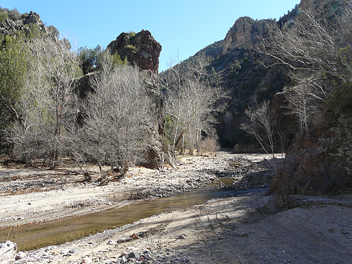
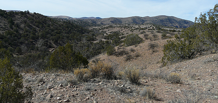
Today, all of this rugged country into which Ulzana vanished, from Soldier Hill west along Little Dry Creek Canyon to its convergence with Big Dry Creek Canyon and then on the San Francisco River, lies within the Gila National Forest and is open to the public. It is a highly diverse and fascinating landscape. No matter what your interest, be it frontier history, nature photography, geology and rockhounding, unusual riverine forest and high desert plants, birding, wildlife, or simply exploring wild, pristine and uncommon natural places, a hike down Little Dry Creek promises a unique and fascinating experience.
A LANDSCAPE FORGED IN FIRE AND SCULPTED BY UPLIFT AND RUNNING WATER
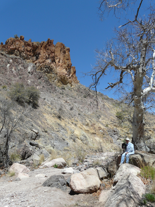
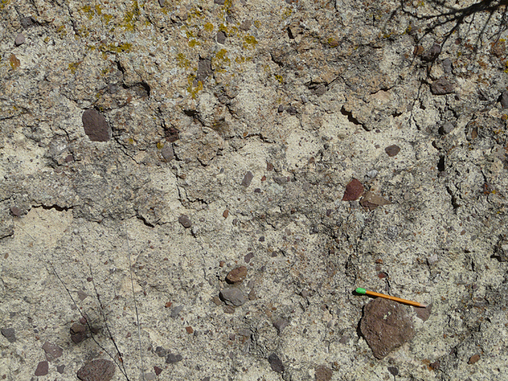
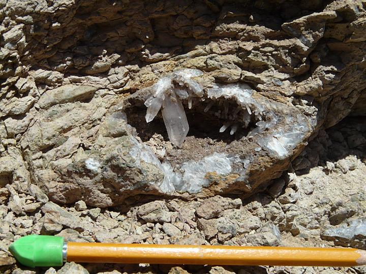
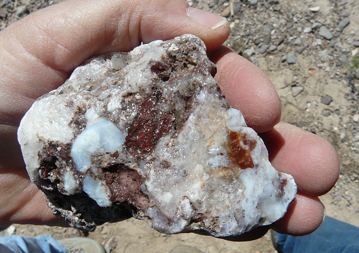
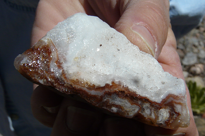
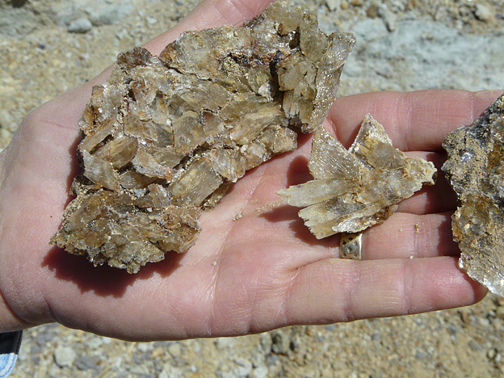
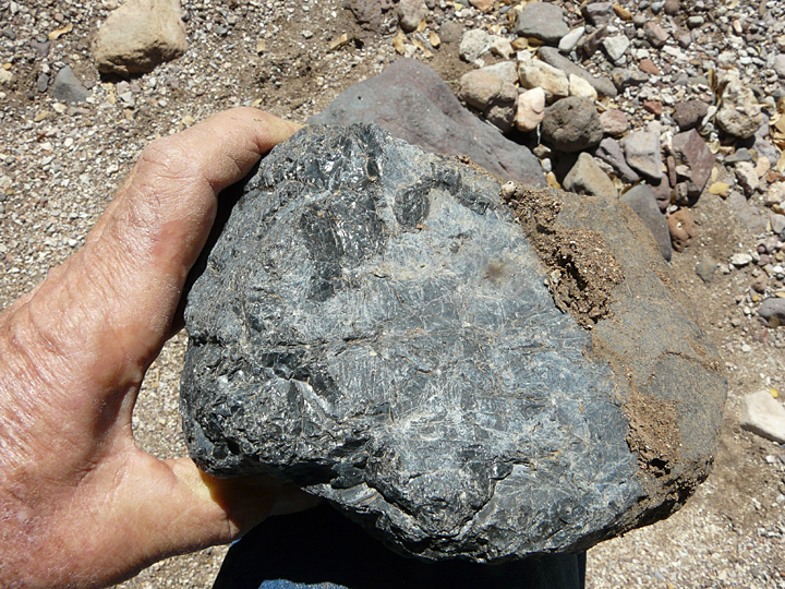
The geology of the Little Dry Creek and Big Dry Creek canyons in the vicinity of the San Francisco River consists of a highly-diverse and colorful assemblage of Middle Tertiary volcanic rocks, most of which were ejected from nearby volcanoes some 26 million years ago during the Late Oligocene Epoch. The range in composition and rock type in this thick sequence of layered volcanics is truly amazing, covering the spectrum from iron- and magnesium-rich basalt flows; to massive, fine-grained to porphyritic andesite flows, which sometimes contain large phenocrysts of andesine or labradorite plagioclase feldspar or flows containing abundant gas bubbles, commonly filled with quartz, calcite and other crystals; to many varieties of silica-rich rhyolite pyroclastic deposits ranging from fine-grained ash fall welded tuffs and pumice to coarse, blocky breccias with a fine ash matrix.

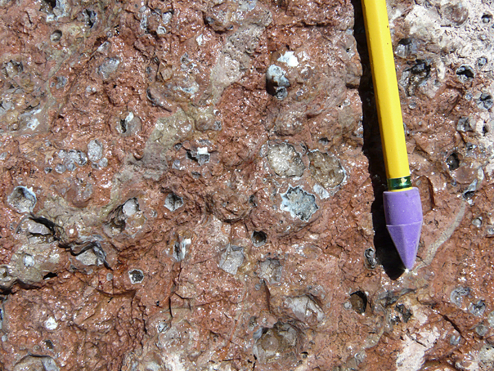
The variation in these rocks along the course of these canyons is amazing, exceptional enough to excite even the most jaded professional geologist or vulcanologist. What it translates to for the layperson (anyone who simply enjoys finding nice rocks) or the more dedicated rockhound looking for good specimens such as geodes or semi-precious material to cut and polish, is a several-mile-long rock and mineral collecting paradise, through canyons that are lined with more unusual and special rocks than your hiking companion can (or is willing to) carry!
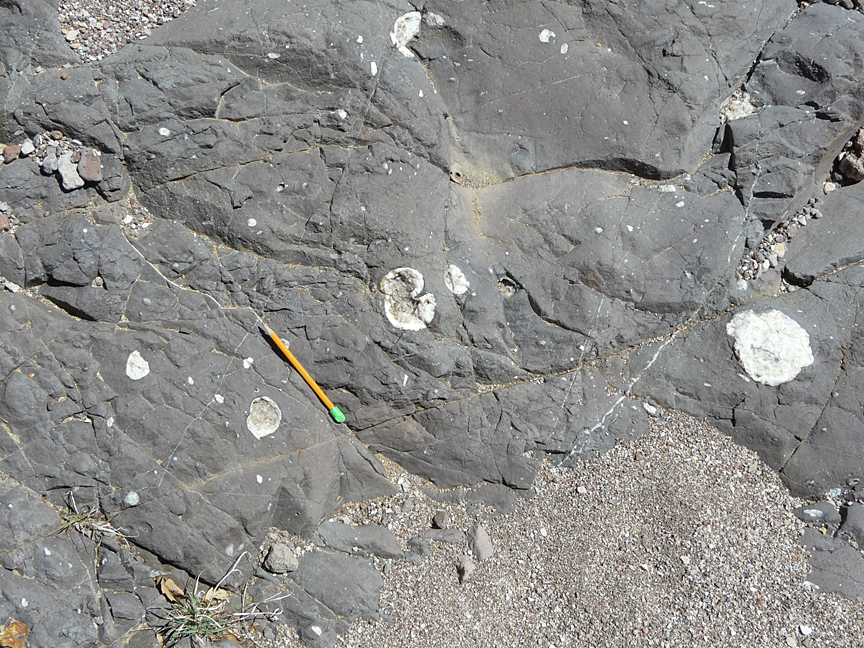
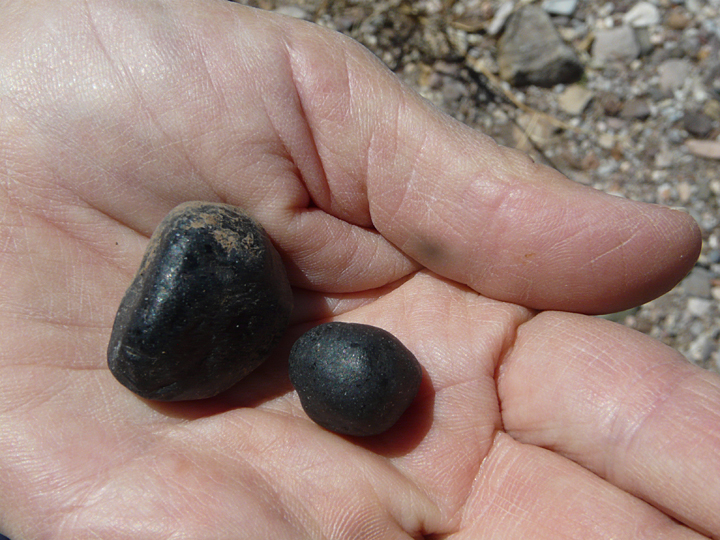
Following the major volcanic eruptions and deposition of the dominant andesite flows in the area 26 million years ago, a period of quiescence took place. Then, between 18 and 20 million years ago, volcanic activity resumed. Once more the fires down below were stoked sufficiently to open numerous small vents at the surface of the earth, followed by the ejection and deposition of more localized formations of silica-rich rhyolite flows and pyroclastic material, plus flows of natural glass in the form of perlite and obsidian. Nodules of this naturally formed glass, technically known as marekanites, or more commonly as Apache Tears, can be found within the loose sediment in transport down the canyons.
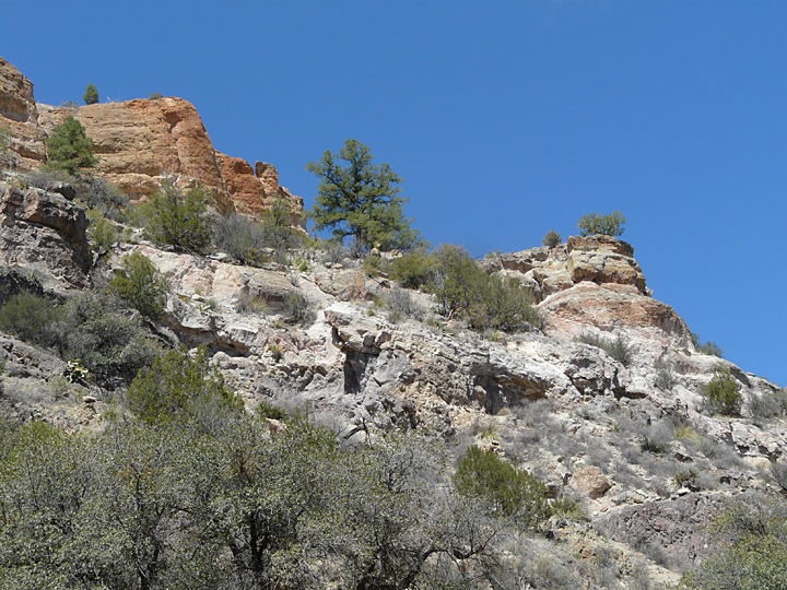
Following the deposition of the older volcanic units, tectonic uplift and movement took place throughout the Little Dry Creek, Big Dry Creek, and San Francisco River region, resulting in extensive fracturing and faulting of the landscape. Most of the faults are high-angle (nearly perpendicular) faults trending NE to NNE and NW to WNW. Faults create linear zones of structural weakness within the rocks they penetrate. As a result, the course and direction of the canyons and side canyons that are found in the area often follow or are influenced by this faulting as a result of millions of years of erosion and downcutting by the numerous creeks and streams flowing across area from the Mogollon Mountains to the east. Many of these major faults, as well as smaller scale faulting, can be observed in the cliffs as one hikes these canyons.

THROUGH CORRIDORS OF ANCIENT, WHITE-BARKED SYCAMORES

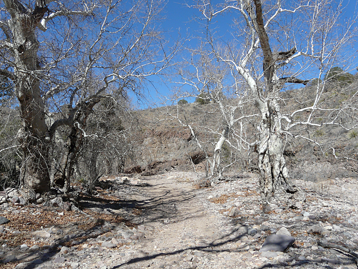
As one hikes deeper into the Little Dry Creek, Big Dry Creek, and side canyons such as Eliot Canyon, the sheer walls of the surrounding volcanic cliffs and mountains rise higher and higher, gradually soaring to heights of 1000 feet or more above the canyon floor. The entombed silence within these canyon depths becomes increasingly pervasive as the canyon wall press ever closer, initially unnoticed until suddenly thrust into palpable awareness by the piercing cry of a soaring raptor from somewhere high above. Steadily, all of one’s senses heighten as the world away fades from mental focus and the immediacy of the Now of Nature entrains one’s mind and soul. But above all, it is the ancient, white-barked sycamores lining and guarding the corridors of these winding canyons that command and mesmerize one’s total awareness, these persevering, mute, ghostly-white witnesses to the centuries-old, eternal pageant of Nature’s periodic rampaging floods and the occasional Human intrusion that have past them by … Oh, what stories they could tell!
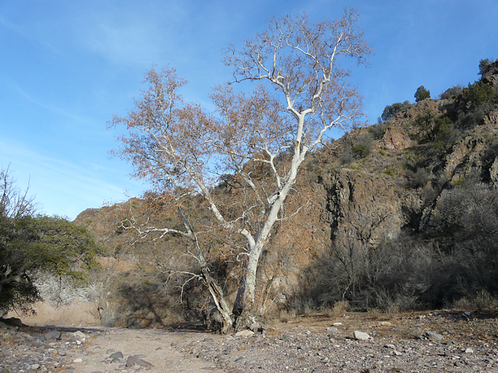
The Arizona Sycamore, (Platanus wrightii) is named for the American botanist Charles Wright (1811-1885) who collected the first specimens in 1851 while participating in the United States and Mexican Boundary Survey. Platanus wrightii is native only to Southwestern New Mexico, Arizona, and Northwestern Mexico. Here it is only found along rivers, streams, and intermittent creeks and streams in rocky canyons, where, even if the canyon is dry at the surface most of the time, a good supply of water is always available in the subsurface alluvial sediments below the valley floor. The Arizona Sycamore is one of the largest deciduous in the Southwest, growing to heights of 80 feet or more. It easily identified by its white-barked upper branches and pastel greenish to reddish gray or tan mottled trunks which flake off in patches revealing a bone-white inner bark. In late October to early November the tree is absolutely spectacular when its large, palmate leaves turn a deep orange to brick red. Later in the season, the beauty of these noble giants increases further when the red leaves remaining on the arching, upper white branches atop the bone-white gnarled and twisted trunks are now silhouetted against the clear, cobalt blue skies of Winter. For the photographer or artist it can be a source of unending inspiration.
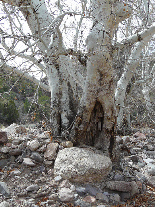
The old saying ”when the going gets tough, the tough get going” could well have been coined by some ardent admirer of Platanus wrightii. For when the canyons get really rocky, and are often subjected to extreme flooding, capable of transporting boulders up to 6 feet or more in diameter, it is here that the the Arizona Sycamore seems to thrive at its magnificent best. Indeed, these sycamores prosper in an environment where other common New Mexico riverine species such as cottonwoods and willows would not even think of putting down roots. And, such is the case in Little Dry and Big Dry Canyons where phalanxes of these ancient, white-barked giants stoically line both sides of the canyons in ongoing benign defiance of their hostile environment. Even more impressive is that some of these warrior sycamores make their stand right out in the middle of the canyon, the bark of their battered and scarred upstream trunks now slowly growing around some huge, oversized boulder that mistakenly thought it could take this tall piece of cellulose out all on its own! Looking at one of these warrior sycamores one can almost hear it calling out to the oncoming boulder during the onslaught of the peaking flood: All right, Pilgrim, come on, give it your best shot!

After becoming somewhat familiar with this “rough country where horses can not go”, one eventually begins to contemplate just what route Ulzana took when retiring from the ambush on Soldier Hill. An indication of this route can be inferred from two facts that were reported at the time: first is that Ulzana and his men retreated to the west, down Little Dry Creek, and second, that four days later, on Christmas Eve, he and his warriors raided the mining community in the vicinity of Carlisle, NM, killing 3 men, wounding 2 or 3 others, and stealing 40 head of horses at Steeple Rock. With these horses the raiders could once more “move like the wind”, crossing the Gila River into Arizona on Christmas Day, and then traveling swiftly south for the next six days, committing much murder and mayhem as they went, before crossing the border into Mexico on December 31.1
With these facts in mind, and studying the land between Soldier Hill and Carlisle, some 30 miles to the south, it seems quite likely that after leaving Soldier Hill Ulzana would have only gone about 2 miles downstream on Little Dry Creek to the west, before turning south into Eliot Canyon. From here they would have had safe passage up rugged Mineral Spring Canyon, following it south upstream to Burnt Stump Creek Canyon, which leads south and upstream to the Mule Mountains. From the Mule Mountains they then could have followed Pine Cienega Creek along well-documented old Indian trails that lead southwest to what is now Brushy Mountain Road and then south along Apache Creek to the Carlisle mining community.
There are many of those ancient white-barked sycamore giants at the junction of Little Dry Creek and Elliot Canyon. For sure they witnessed Ulzana and his men pass by on that December morning of 1885 and know which canyon he chose. So far they haven’t shared this knowledge, but perhaps, just maybe, if one was to spend a little more time with them some afternoon when the red leaves are falling and white branches are soaring into a cobalt blue sky, well, maybe they just might …
As always, we are happy to provide guests staying at Casitas de Gila Guesthouses with detailed directions and maps for this hike, as well as for all the hikes detailed in the Casitas de Gila Nature Blog and on our website. All one needs to do is ask!
IMPORTANT NOTICE AND ADVISORY REGARDING TRAIL CONDITIONS FOR LITTLE DRY CREEK
While this hike is an excellent easy to moderate hike across level terrain in unique and spectacular country, visitors are strongly advised to inquire as to local existing conditions regardless of the time of the year, before taking this hike. The reason for this caution is that while Little Dry Creek and Big Dry Creek are, as their name implies, dry most of the year, there are certain times when both are subject to sudden flash floods of depths of 8 to 10 feet or more, especially during the Summer Monsoon season between late June and early September. While this is not a problem for the first one-half mile or so because of the broad floodplain and accessible adjoining hillsides, beyond this point the canyons are frequently narrow, with sheer vertical rocky cliffs on both sides, and where water will run deep the width of the canyon. While in most places one could access higher ground out of the reach of the flood waters, one could be stranded for a few hours … or possibly a day or more until the water recedes! Both of these creeks have their headwaters in the high Mogollon Mountains a few miles to the east, and because of the steep gradient of the creek bed, the rate of flow can exceed speeds of 20 miles an hour. Also, during the Spring months of February through May, melting snowpack in the Mogollons can often result in weeks of prolonged high runoff when the trail would not be passable in many places.
REFERENCES
1. Edwin R. Sweeney, 2012, From Cochise to Geronimo: The Chiricahua Apaches, 1874-1886, University of Oklahoma Press.
