There's plenty to do in the Silver City Area …
Come and visit the Silver City area and stay at Casitas de Gila Guesthouses! We are the ideal location for a quiet and relaxing stay! There is lots to do and many, many places waiting to be discovered by new visitors and by frequent visitors. Here are some of them. And don't forget: We have over 7 miles of hiking and walking trails right on our property, and the best New Mexico birding around!
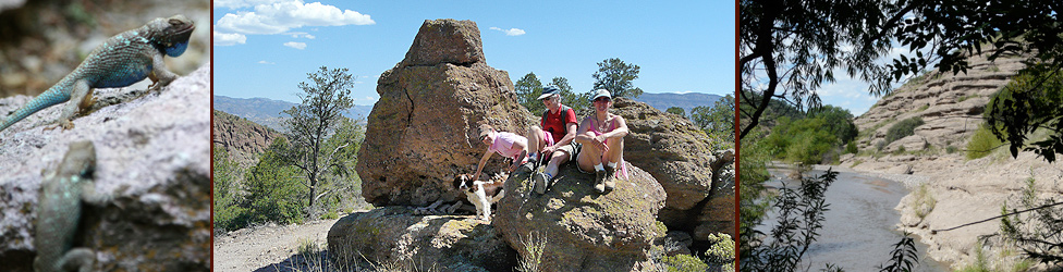
HIKING & BIRDING EXCURSION to the Middle Box of the
Gila River in the Burro Mountains
 The Burro Mountains are a rugged, north-south chain of mountains about a few miles west and northwest of Silver City that include some 250 square miles of the Gila National Forest. Extensive trails and primitive four-wheel drive roads crisscross the forest lands offering varied opportunities for hiking, birding, mountain biking, four-wheeling, fishing, and exploring. The Burro Mountains are a rugged, north-south chain of mountains about a few miles west and northwest of Silver City that include some 250 square miles of the Gila National Forest. Extensive trails and primitive four-wheel drive roads crisscross the forest lands offering varied opportunities for hiking, birding, mountain biking, four-wheeling, fishing, and exploring.
One of the best areas for hiking, birding, and general nature study in a pristine river environment is a day trip to the Middle Box of the Gila River at the northern end of the Burros. Here you will find two birding areas on the Gila River and the trailhead for Forest Trail 746. Forest Trail 746 leads south along the east bank of the Gila River for 3/4 mile before crossing to the west side of the river. Another 1.3 miles will take you to a great swimming hole and picnic spot. The trail is well marked over essentially level ground within the Gila River floodplain with rock cairns marking the way in areas of sparse vegetation, and passes through magnificent groves of cottonwood and sycamore. Birds, animals, and diverse riparian plant species abound. Beautiful!
A side trip to Bill Evans Lake affords excellent birding for waterfowl species, as well as great fishing.
For our guests at Casitas de Gila Guesthouses, we are happy to provide directions and maps.
You can read a full description of this hike in Michael's Gila Nature Blog.
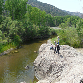
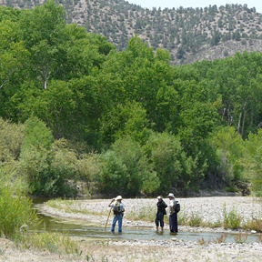
HIKING & BIRDING EXCURSION in the Nature Conservancy
Gila Riparian Preserve within the Upper Box of the Gila River
 The Gila River Riparian Preserve is a 1,200+ acre preserve that is open to the public, situated within the Upper Box of the Gila River, and surrounded by the Gila National Forest. Its spectacular surroundings offer incredible opportunities for birding, wildlife viewing, and general nature study. The area offers unlimited access to the Gila River as it emerges from the Gila Wilderness to flow through magnificent groves of old-growth cottonwood and sycamore that are hundreds of years old. An easy 2-mile hiking trail along the west side of the river follows a 4-wheel-drive access road that leads to the Gila River Flow Gaging Station. Take a picnic lunch with you to enjoy under the trees along the river just below the gaging station. You might even see a coatimundi! The Gila River Riparian Preserve is a 1,200+ acre preserve that is open to the public, situated within the Upper Box of the Gila River, and surrounded by the Gila National Forest. Its spectacular surroundings offer incredible opportunities for birding, wildlife viewing, and general nature study. The area offers unlimited access to the Gila River as it emerges from the Gila Wilderness to flow through magnificent groves of old-growth cottonwood and sycamore that are hundreds of years old. An easy 2-mile hiking trail along the west side of the river follows a 4-wheel-drive access road that leads to the Gila River Flow Gaging Station. Take a picnic lunch with you to enjoy under the trees along the river just below the gaging station. You might even see a coatimundi!
For guests at Casitas de Gila, we are happy to provide directions and maps to this beautiful spot.
A DAY TRIP through the Gila National Forest …
PINOS ALTOS
Take NM 15 north at its intersection with US 180 in Silver City and drive seven miles to Pinos Altos (Tall Pines in Spanish). Pinos Altos began as an early Grant County mining town when gold was discovered nearby in 1860. The town still retains its historic feel and much of its original architecture. Visit the Museum, the "Fort", the old Post Office/Ice Cream Parlor, the Hearst Chapel, and the Buckhorn Saloon & Opera House (closed Sundays).
Watch a 3-minute video on Pinos Altos and the Buckhorn Saloon, produced by New Mexico True Television.
CHERRY CREEK CAMPGROUND
Take NM 15 about 5 miles north of Piños Altos .On the east side of NM 15 is Cherry Creek Campground, where you will find good birding and a nice place to stretch your legs.
SIGNAL PEAK
Signal Peak is a beautiful 2-1/2 mile hike (5 miles round trip) up one of the highest peaks in the Piños Altos Range, surrounded by wildflowers in season. The trail leads to the Signal Peak Fire Tower, where you will find 360° views at about 9,000 feet elevation.
GILA HOT SPRINGS
Located about 40 miles north of Silver City, 4 miles south of the Gila Cliff Dwellings National Monument, Gila Hot Springs is the remains of an old ranching community settled in the 1880s by the Hills Brothers. It was once the site of a military camp established to guard local homesteaders. Operated by the Campbell family since 1940, soaks in the hot springs are available for $3 per person.
THE LOOP — TRAIL OF THE MOUNTAIN SPIRITS
Returning south from Gila Hot Springs on NM 15, for some different but equally spectacular scenery before returning to the peace and quiet of Casita de Gila, take NM 35 and loop through the beautiful Mimbres River Valley. Where NM 35 dead ends at the intersection of NM 152, turn right to return to Silver City and then on to Casitas de Gila. Although this route is a bit longer than simply retracing your steps, you will avoid the winding roads of NM 15.
LAKE ROBERTS
Stop at Lake Roberts, near the intersection of NM 15 and NM 35. Lake Roberts is a 72-acre man-made lake in the Gila National Forest. Fed by Sapillo Creek, the lake can be fished for 10 to 14 inch rainbow trout (best late March to late May), as well as crappie, catfish, and some bass. An oasis for wildlife, it's common to see herds of deer grazing along the road near the Lake. There are numerous trails leading into the forest and a self-interpretive Mimbres Indian site.
CONTINENTAL DIVIDE TRAIL
A little farther down NM 35, look for the Continental Divide National Scenic Trail, a long, primitive hiking route. The loop made by the Trail of the Mountain Spirits crosses the Continental Divide Trail twice, accessing a 14-mile-long segment through forested country that is a visual feast of butterflies, birds, and wildflowers.
SANTA RITA COPPER MINE
Returning to Silver City via "the Loop" and NM 152, you will pass the natural rock formation known as the Kneeling Nun. Beneath it lies the former town site of Santa Rita, now swallowed by the gaping pit of the Chino Copper Mine. Metal has been extracted here for over two centuries, and for a few years in the early 1800s local copper supplied the Spanish Royal Mint in Mexico City, making the torturous 1,300 mile frontier journey by mule train.
A DAY TRIP to Fort Bayard & City of Rocks
FORT BAYARD HISTORIC SITE & THE "BIG TREE"
Established in 1866, Fort Bayard was an important military outpost whose troops, including the famous Buffalo Soldiers, protected the local mining settlements of Piños Altos and Santa Rita. The last active troops left in 1900, at which time the post became a medical facility. Currently, Fort Bayard is a wildlife refuge known for its resident elk herd. There are some enjoyable short interpretive walks through the old parts of the fort.
To tour the fort, turn north from U.S. 180 at the traffic light in Santa Clara onto the Fort Bayard Medical Center access road. From Fort Bayard you can hike to an immense alligator juniper known as the "Big Tree".
The Big Tree is ranked as the second largest alligator juniper in the country. It is 63 feet high with a trunk diameter of 70 in., circumference of 18 ft., and crown spread of 62 ft. The tree is accessible by hiking a 5.5 mile round trip through piñon and juniper in the foothills of the Piños Altos Range. To visit the Big Tree, drive past the hospital complex by taking the right fork and follow the signs to the Forest Administrative Site and National Recreational Trails (4.5 miles up the Ft. Bayard Nursery Road). The parking lot for the trail is 1/10 mile left of the fenced Administrative Site.
DRAGONFLY PETROGLYPH SITE
From the traffic light at 32nd Street Bypass Road (just past the Ace Hardware), go 3.4 miles and turn left on Arenas Valley Road. Follow Arenas Valley Road northward 1 mile to the parking area at the sharp curve. Hike the more traveled trail to the right, and in about 200 yards the trail forks to make the well-marked 3.5 mile Dragonfly Loop Trail. There are several nice petroglyphs in the rocks halfway, indicated by an arrow on a wordless sign. Arenas Valley Road is a short loop, so it is possible to continue along it back to US 180 as you turn to Silver City.
CITY OF ROCKS STATE PARK
City of Rocks State Park, located 30 miles south of Silver City, has rock formations so unique they are known to exist in only 6 other places on earth. Billowing volcanic ash from ancient eruptions far greater than Mt. Saint Helens welded itself together by intense heat, then slowly eroded through wind and water into fantastically sculpted shapes. Besides geology, visitors can experience a variety of southwestern plant and animal life native to the Upper Chihuahuan Desert ecosystem. The Park’s desert botanical garden is home to cow's tongue and bunny ear cacti, yucca, and towering century plants. Deer, antelope, javelina, and jackrabbits are frequently seen in the area, along with over 35 species of birds ranging from Golden Eagles to finches.
Watch a 3-minute video of City of Rocks State Park produced by New Mexico True Television.
Take US 180 east and south from Silver City. Travel through Bayard and past Hurley and the mine tailings of the Santa Rita pit. Turn left on NM 61 and drive 4 miles northeast to the state park access road. Park hours are 7 AM to 9 PM and the entrance fee is $5 per vehicle.
FAYWOOD HOT SPRINGS
Near the City of Rocks on Highway 61, about 2 miles from its intersection with U.S. 180, is Faywood Hot Springs, a high desert oasis with many geothermal pools of different temperatures. A century and a half ago the refreshing mineral springs served as a resting place for two different stage lines running between the tiny but important settlements of Mesilla and Pinos Altos. By 1896 a hotel with 60 guest rooms, considered the finest in all New Mexico Territory, stood here, but by 1951 the hotel was gone and things had calmed down considerably. Faywood Hot Springs has a number of outdoor public and private soaking pools and is open from 10 AM to 10 PM.
A DAY TRIP to Historic Silver City
Silver City hosts a variety of galleries, gift shops, historic buildings, fine restaurants and bars, coffee shops and quaint homes. It is definitely worth exploring by foot. For it's history and archaeology, a visit to the Silver City Museum and Western New Mexico University Museum are a definite must.
SILVER CITY MUSEUM
Silver City has a fascinating history, from Apache campground to Spanish settlement to bustling tent city mining camp. "The Big Ditch", now a linear park behind Bullard Street (the current main street of town) was originally Main Street until thunderstorms in the early 1900s flooded the town and simply washed the street away. A young Billy the Kid once lived nearby. You can learn more about the town's rich history at the Silver City Museum, housed in a restored 1881 mansion at 312 W. Broadway. Open Tuesday thru Friday 9 AM to 4:30 PM and Weekends 10 AM to 4 PM. $3 per person suggested donation. 575-538-5921.
WESTERN NEW MEXICO UNIVERSITY MUSEUM
Home to the largest permanent collection of prehistoric Mimbres Pottery in the world, along with basketry and other artifacts. The collection includes Casas Grandes pottery, Maria Martinez, San Ildefonso and Santa Clara pottery, heirloom Navajo rugs, historic photographs of Silver City and surrounding areas, and traveling exhibits. The museum is on the University campus in Fleming Hall, 1000 W. College Avenue, at the west end of 10th Street. Open Monday thru Friday 9 AM to 4:30 PM and Weekends 10 AM to 4 PM. Closed over school holiday periods.
BOSTON HILL
Take a hike on Boston Hill. Just off Market Street above downtown. Boston Hill offers 12 miles of trails winding in and around many of the old mines above Silver City, giving the hiker a spectacular view of town and the surrounding area.
A DAY TRIP to the Deming Area
COOKE'S PEAK
Driving south towards Deming on US 180, the distinctive landmark on your left is Cooke’s Peak, 8,000 feet in elevation. The mountain honors Phillip St. George Cooke, who led the US Army’s Mormon Battalion through the area in 1846 while scouting an overland wagon route for frontier military use. Later, a Butterfield Overland Stage station and then a Pony Express station operated at the nearby spring. The Army constructed Fort Cummings near Cooke’s Spring in 1863 as protection from Apaches, and staffed it intermittently until Geronimo surrendered in 1886. Later, the Cooke’s Peak Mining District produced much metal, predominantly lead and zinc, through the years.
DEMING LUNA MIMBRES MUSEUM
Located in downtown Deming at 301 S. Silver Street, the red brick Museum was originally the first New Mexico National Guard Armory begun after statehood in 1912. Completed soon after Pancho Villa’s 1916 Raid on Columbus, the Armory later served as a community social center and a USO. Displays include artifacts and pottery of the Mimbres culture, rocks and geodes, and historical, military, and ranch life exhibits. This incredible community museum is open daily 9:00 AM to 4:00 PM. Closed Sunday during the summer. Admission is free, but donations are welcome. 575-546-2382
ROCKHOUND STATE PARK
Perched on the rugged slopes of the Little Florida Mountains 13 miles from Deming, the rocks and semiprecious gemstones in this park are yours for the taking. Search for agates, quartz, jasper, opals, and translucent chalcedony in many shades. There are short hikes and panoramic views from the highest northeast shelter. From Deming, take NM 549 east seven miles, then south on NM 143. Open daily, 7:30 AM to sunset; entry fee is $5 per vehicle. 575-546-6182
COLUMBUS, NM
Thirty miles south of Deming is Columbus, New Mexico, the U.S. town famously attacked by Mexican revolutionaries under Pancho Villa on March 9, 1916. Pancho Villa State Park preserves the grounds of the former Camp Furlong, one of a string of army posts protecting the US/Mexico border from marauders and bandits. The park office is an original structure, as is the adjacent dining hall. The park’s 49 acres feature beautifully xeriscaped grounds and a new 7,000 square foot Exhibit Hall with displays relating to the raid and the Army’s subsequent Punitive Expedition against Villa, which marked the Army’s first use of automobiles and airplanes in warfare. Highlights include a Curtiss “Jenny” biplane like those flown by the 1st Aero Squadron and a 1916 Dodge Touring Car such as used by General “Black Jack” Pershing as a field office. There are also walking paths and well-labeled botanical gardens. The Exhibit Hall is open from 8:00 AM to 5:00 PM daily. Entry fee: $5 per vehicle. 575-531-2711
The town of Columbus itself hosts a museum, The Shrine to the Perfect Man, and, on its northwestern edge, The City of the Sun, a community with some unique one-of-a-kind earthship homes built of “green” materials such as papercrete, tires, adobe, and discarded bottles.
Check out more activities on our Things To Do page! |