Documenting a Major Flash Flood on Bear Creek at Casitas de Gila Guesthouses
caused by Remnants of Hurricane Odile in Southwest New Mexico
THE SETUP: HURRICANE ODILE MAKES LANDFALL
ON MEXICO’S BAJA CALIFORNIA PENINSULA
On Sunday night, September 14, 2014, Hurricane Odile came ashore on Mexico’s Baja California Peninsula, making a direct hit on the resort tourist destination of Cabo San Lucas as a Category 3 hurricane with sustained winds of 125 mph. It was the strongest hurricane to hit the Peninsula in recorded history. After inflicting devastating damage and chaos in Cabo, the hurricane took an unusual northward path along the Baja Peninsula towards Arizona, reaching the U.S. border on Friday, September 19. Passing into Arizona, the storm then took a turn to the east towards Southern New Mexico and West Texas. Although the winds rapidly decreased upon entering the U.S., the degraded storm succeeded in dragging a huge plume of moisture into the Southwest, triggering several days of rain and thunderstorms as it travelled eastward, and resulting in extreme flooding and flash floods in SE Arizona and SW New Mexico.
A NIGHT TO REMEMBER
The National Weather Service (NWS) had predicted that over the weekend and early into the coming week of September 22 there would be a high probability of showers and thunderstorms, with some local flooding and flash floods as the remnants of Storm Odile made its way from Arizona east towards Texas. Indeed, on September 20 and 21, patchy showers, thunderstorms and localized flooding occurred throughout Southwest New Mexico, although only small amounts of rain and only a brief, small rise in Bear Creek were recorded at the Casitas. By Sunday evening, September 21, NWS radar was showing that the most intense thunderstorm activity stemming from the rapidly-dissipating Odiel had now moved east of the Casitas and the surrounding Gila area towards Truth or Consequences, NM, suggesting that the potential for significant flooding was over. Such was not the case.
At about 2 AM on Monday morning, September 22, the first of several large thunderstorms made a direct hit on the Casitas. With the pounding of the first blast of rain on the roof, a check with the NWS radar showed that the thunderstorm cell had come out of the Northeast. With increasing consternation, it was quickly determined that not only was it a large cell, but there were several large cells lined up behind it, all of which were tracking straight towards the Casitas. Taken together, the numerous cells covered a wide swath that essentially covered the entire drainage basin of Bear Creek, extending all the way upstream from the Casitas to Pinos Altos, 25 miles to the northeast. If these cells remained active for any length of time, it was pretty certain that Bear Creek was going to flood. Judging by the persisting deep red to purple colors of the cells on the radar as they slowly moved down Bear Creek, it was going to be a major flood.
All of the thunderstorm cells remained intensely active until 4 AM, when the last of them finally passed over the Casitas. By this time Bear Creek was already roaring unseen in the darkness 100 feet below in the canyon below the Casitas. By the sound of it, a significant flash flood was underway, but it would be another two and a half hours before the first light of day would illuminate the magnitude of what was actually taking place.
A FLOODPLAIN OF CHANGE
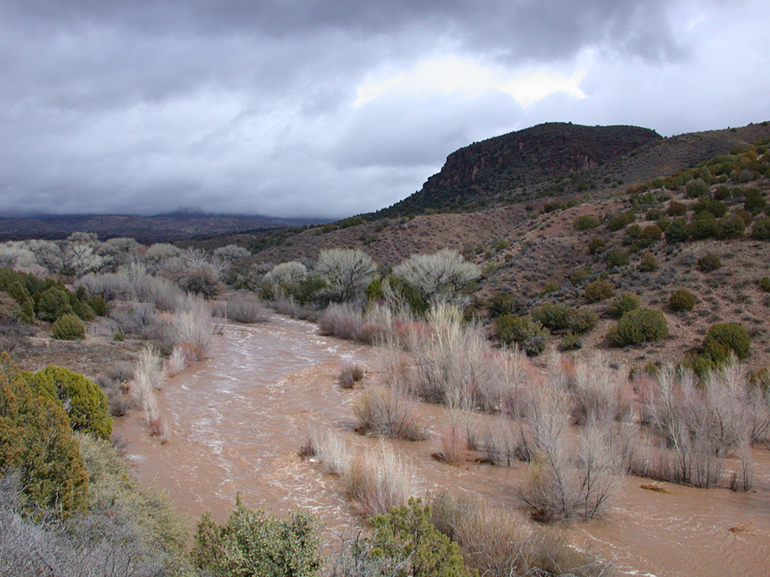
Peering down into the canyon in the early morning light, one could see that the peak of the resulting flash flood had already passed by and that Bear Creek was still swollen out of its banks and running strong.
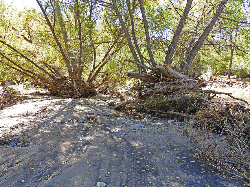
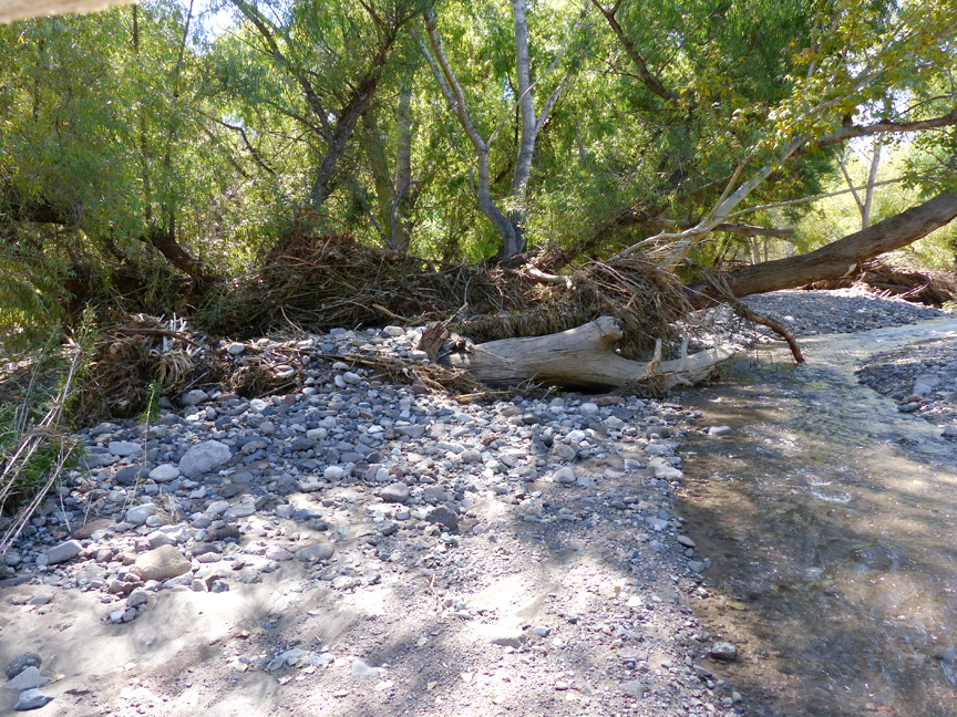
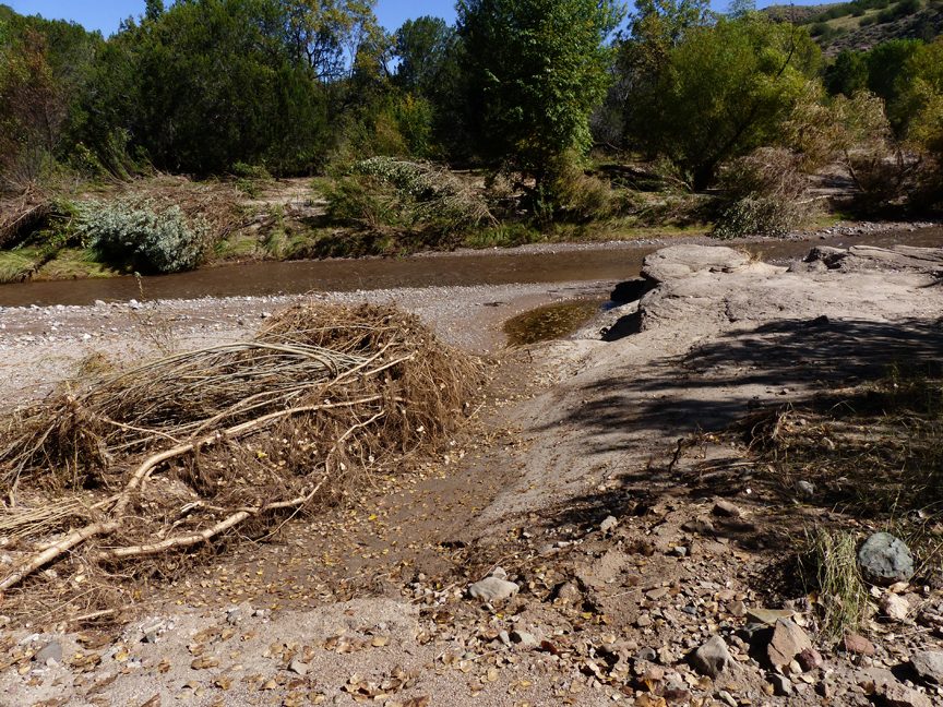
Here and there chaotic masses of vegetative debris could be seen hanging high in the branches of the cottonwoods and willows several feet above the floodwaters that still ran across the entire floodplain and onto the adjacent stream terraces below. Over the main channel an endless parade of logs, branches, and mats of other floating debris shot by in the churning waters.
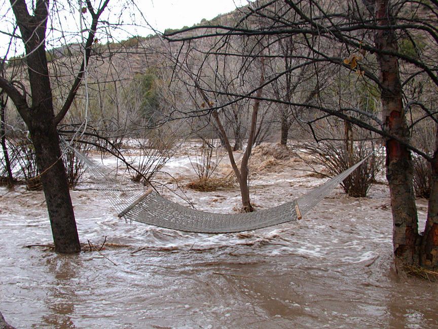
Late in the day on Monday, when the Creek had dropped substantially from its highest stand, some guests staying at the Casitas ventured down to take a closer look at the still roaring Bear Creek, following a trail that leads down to a hammock that is situated on a creek bank terrace about 6 feet above the main channel, on the Casita side of the Creek. Upon their return they estimated that the hammock (still intact and hanging on its chains) had been submerged about 2 feet underwater at the peak of the flood on the basis of debris caught in adjacent trees, which would put the maximum depth of the Creek over the channel at about 10 feet. If verified, this figure would mean that the September 22 floodwaters had attained the greatest depth of any flood experienced in the 16-year history of Casitas de Gila Guesthouses, the previous record being an 8-foot depth from the February 12, 2005 flood. That flood had resulted when a warm front coming up from Mexico brought 2.5 inches of slow rain to the area over a 52-hour period, which succeeded in melting all of the snow pack in the high mountains of the Gila Wilderness lying a few miles north and northeast from the Casitas.
It would be three days before the floodwaters receded to the main channel and the velocity dropped enough that one could cross the creek safely to survey and record what had taken place. Starting at the downstream boundary of the Casita land and following the course of the Creek two-thirds of a mile to the upstream Casita boundary, a close inspection revealed that the guest’s estimate was actually conservative in that the floodwaters had in places reached depths of 11 to 12 feet, based on debris lodged in the trees bordering the main channel.
SOME BASIC PROCESSES OF STREAM CHANGE IN BEAR CREEK
Before illustrating and discussing the changes that took place on Bear Creek over the three-day period of September 22-25, 2014, it is useful to review some of the basic processes that affect how a stream evolves and changes over time.
The width of the active Bear Creek floodplain over the Casita lands, including the first stream bank terraces, varies from 120 feet at the most narrow point to 250 feet at the widest. Although rather confined, over time the Creek still manages to display some of the features of a meandering stream. In the 16 years of observation at the Casitas the stream has undergone significant change, including:
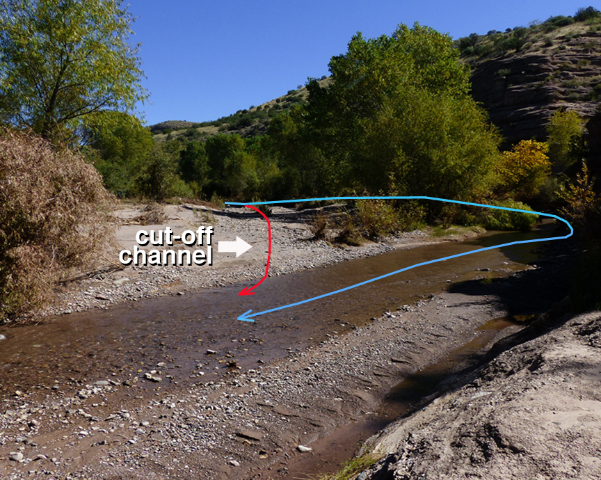
- Channel migration or meander from one side of the canyon to the other, producing slip-off slopes, point bars, stream cut cliffs, and cut-off channels or chutes
- Deposition and build up of sediments up to 6 or 7 feet thick across the floodplain, ranging from fine sand to boulders 3 feet in diameter
- Erosion and scouring of cut-off channels up to 6 or 7 feet deep
- Exposure or burying of the Gila Conglomerate bedrock underlying Bear Creek by unconsolidated modern sediments in transport down the Creek

All creeks and rivers carry various amounts of solid sediment and dissolved matter downstream. This material is referred to as stream load, which is classified into three types:
- Bed load – Coarse and heavy sediment, ranging in grain size from silt and sand to pebbles, cobbles, and boulders, that travel downstream along the bottom of the stream either in constant contact, such as rolling or sliding (traction load), or by hopping and skipping and bouncing (saltation load)
- Suspended load – Fine sediment, such as clay, silt, and sand, that is transported downstream suspended in the water column by turbulence and currents
- Dissolved load – Invisible to the eye, this type of stream load consists of chemical ions of various elements that are dissolved in the water
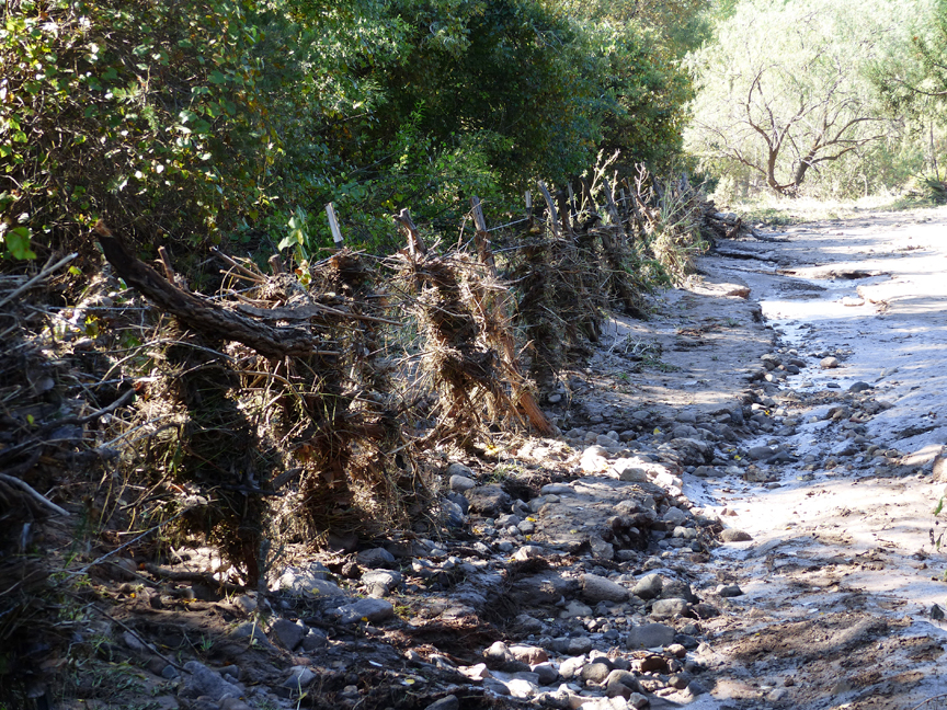
All streams, from small creeks to large rivers, are typically in a state of dynamic flux, attempting to achieve a state of equilibrium where there is neither erosion nor deposition of stream load along the stream channel. Such equilibrium is only rarely and briefly achieved as fluctuation in the volume and velocity of water, plus the gradient or slope of the channels, vary constantly. During floods and flash floods such fluctuations increase exponentially, both in magnitude as well as spatially, as flood waters leave their channels and flow out across the floodplain, and, in the case of large floods, ultimately submerge the adjacent river bank terraces. When the floodplain is covered with riverine forest, as is the case of Bear Creek in front of the Casitas, the resulting fluctuations are extremely chaotic as trees are undercut and topple or masses of floating debris of logs and vegetative matter lodge against standing trees forming localized dams to the churning waters.
A PHOTO DISCUSSION OF THE EFFECTS OF THE GREAT BEAR CREEK FLASH FLOOD OF SEPTEMBER 22, 2014
A Comparison of the Magnitude, Duration, and Effects of the 2005 and 2014 Floods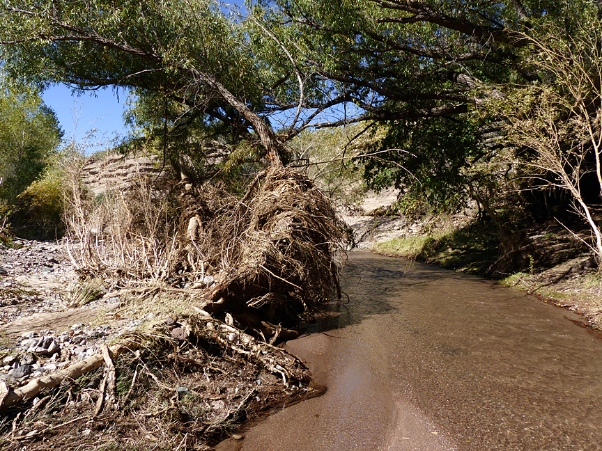
In terms of duration, the 2005 flood went on relatively unabated for nearly two weeks because of a warm front that came up from Mexico dropping 2.5 inches of widespread rain over a period of 52 hours that covered not only the entire Bear Creek drainage system, but also melted all of the snowpack in the adjacent mountains. In contrast, the 2014 flood was essentially a flash flood resulting from only a few hours of intense thunderstorms having extreme precipitation rates of 1 to 2 inches per hour that were confined to the center of the Bear Creek drainage basin. So while the 2014 flood reached greater depths, much greater volumes per second, and higher velocities, this greater intensity only lasted a few hours in comparison to the less intense, but much longer lasting 2005 flood.
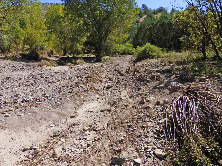
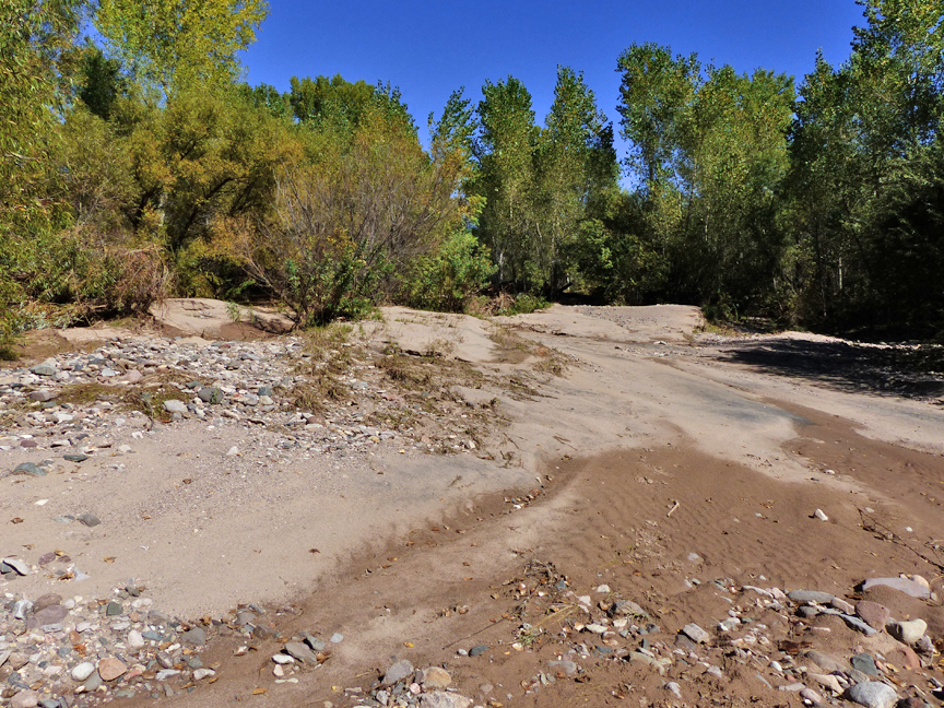

Consequently, the change affected by these two floods upon Bear Creek Canyon was quite different. These changes can be summed up as large scale but gradual changes affected by the 2005 flood as opposed to small scale but catastrophic changes for the 2014 flood. For example: in the 2005 flood the main channel of Bear Creek was shifted from the eastern edge of the canyon some 200 feet to the west to where it is now located directly below the Casitas on the western edge of the canyon. By contrast, the 2014 flood produced numerous, but localized, deeply scoured channels and thick, irregular mound-shaped deposits of sand to coarse gravel and boulders across the floodplain, as well as uprooting trees and stripping vegetation from bedrock surfaces.

Another critical factor responsible for the vast difference in affects resulting from the 2005 and 2014 flood is the dramatic increase in floodplain vegetation between June 2005 and September 20, 2014 (just two days before the flood) as illustrated in the these photos.
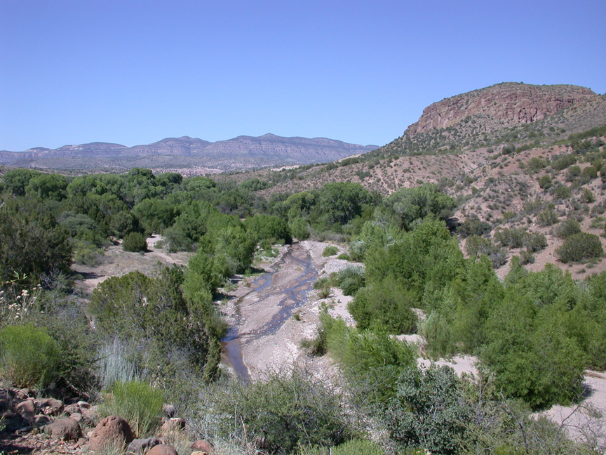
In addition to the increase in density of the maturing riparian forest over the floodplain, note how the main channel in 2014 has become constricted in width, resulting in both active down cutting of the main channel itself while simultaneously forcing a high volume of rapidly-moving water out across the floodplain. The result of these high-energy flood waters surging across the densely-forested floodplain produced massive change across the floodplain in terms of the erosion and scouring of new cut-off channels, plus large-scale build-up of adjacent stream bank terraces of both fine and course suspended and bed load material in response to localized damming effects of flood-transported debris being caught against trees on the floodplain which resulted a reduction in the velocity of the water resulting in deposition of stream load.