BEAR CREEK IN JUNE: A BRIGHT GREEN OASIS
IN A HIGH-DESERT LANDSCAPE WAITING FOR THE RAINS TO COME
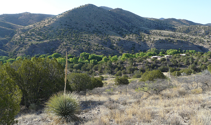
MAY AND JUNE: DRYING TIME IN THE HIGH DESERT SOUTHWEST
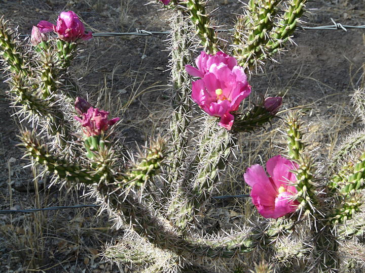
It is late into the “waiting for the rain time” again here at Casitas de Gila Guesthouses on Bear Creek in Gila, New Mexico. It has been a dry Spring with only minimal precipitation, the predictable result of a prevailing neutral to weak La Niña climatic condition over the past Winter that has left the surrounding high desert hills along Hooker Loop in Southwest New Mexico looking somewhat parched and brown. Standing out in scattered counterpoint against the dominant drab browns and tans of the rolling landscape are the ubiquitous deep green One-seed Juniper trees and clumps of Honey Mesquite, now decked out in their sporty new lime-green foliage and fragrant racemes of golden flowers. Most of the stock tanks on the surrounding ranches are already or soon will be totally dry. It’s not as dry as it has been in some years, however, as one observes that a few of the Soap Tree Yucca and Sotol have sufficient water to put up their marvelous flowering stalks, and most of the Cane Cholla are now bedecked in their annual flourish of magenta blooms.
Also, some of the Scrub Oak, particularly those on north- and east-facing slopes, have already replaced their recently shed, tan, dead leaves of last year with new, small olive-green leaves. The others, particularly those on the drier hilltops and south-facing slopes, will wait patiently, of course, for the rains that are soon to come.
BEAR CREEK CANYON: VERDANT OASIS IN A HIGH DESERT LANDSCAPE

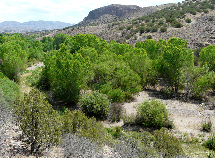
Sitting in front of one’s Casita gazing down into Bear Creek Canyon, however, is to witness a totally different landscape altogether than that of the surrounding hills. Here, a mere hundred feet below, the vegetation is lush — very lush! — with all plants and trees in full foliage, a verdant oasis of a thousand shades of green. It is a time when animal and bird life of all types migrate into the Bear Creek drainage as more of natural sources of water in the surrounding hills dry up.
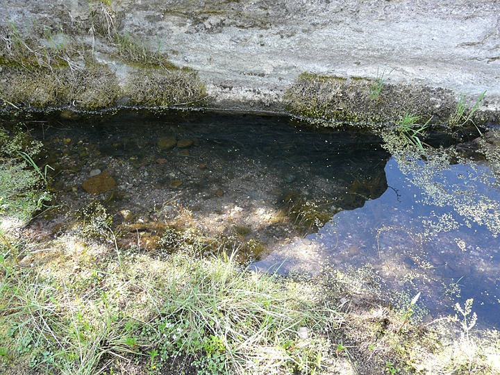
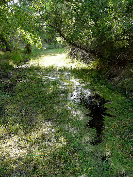
This year, up until the last couple of weeks or so, Bear Creek has been running the full length of the Casita property. But now, after a solid week of higher temperatures and low humidity, stretches of the Creek have gone dry as the water table dropped another two or three inches in response to the increased uptake of water by the dense riverine forest. Nevertheless, the Creek is still flowing, albeit out of sight, just a few inches below the surface of the stream bed. That this is so is quickly evidenced if one digs a shallow hole or simply walks the stream bed until one comes upon one of the natural depressions scoured by the stream during a previous flooding event, which remain full of water.
Depending upon the depth of these “water holes” and their location relative to 1) the thickness of sediment over the underlying bedrock, 2) the composition of the stream bottom sediments underlying the water hole, 3) the amount of shade from direct exposure to the mid-day sun by water plants or overhanging vegetation, or 4) the possible presence of one of the numerous springs that exist in the bottom of Bear Creek Canyon, these water holes may or not persist until the Monsoon rains begin and the water table of Bear Creek is raised. Having observed these life-sustaining waterholes over the past 14 years, one is aware there never has been a year when at least some of these water holes remained, providing habitat and sustenance for an extremely wide variety of animal species for both year-around and seasonal creek and canyon residents, as well as adjacent upland dwellers.
ROCKY MOUNTAIN SHEEP ON THE CLIFFS:
A SIGN THAT MANY OF THE UPLAND SOURCES OF WATER HAVE DRIED UP
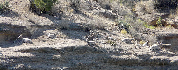
Over the past two weeks a large group of Bighorn Sheep have been frequenting the sheer cliffs of Gila Conglomerate that line the east side of Bear Creek Canyon across from the Casitas. From past observations, this annual event is a sure sign that the upland stock tanks and natural springs and water holes are drying up. This year the group consists of seven ewes, one young adult ram, and five of this year’s lambs. For our guests and ourselves it is always a great treat to watch the lambs scamper around in death-defying abandon on the 120-foot-high vertical cliffs under the ever-watchful eyes of the adults!
This year the sheep have been coming in for two or three days and nights at a time, where their daily routine consists of grazing on the shrubby vegetation and taking mid-day siestas along the top of the cliffs. Periodically they leave the cliffs to descend to the creek bed below to feast on the succulent fresh green grass lining the creek and to drink from the cool, clear water holes at the base of the cliff. Around dusk the sheep retire to the security of narrow ledges high on the cliffs. Here they will bed down for the night, a relatively safe haven from their two primary predators: the mountain lion and the coyote. Members of the Bear Creek Bighorn Sheep herd have been frequent and regular visitors to the cliffs every year since the Casitas opened nearly 15 years ago. In recent years, however, one has noticed that their visits to the cliffs have been of much shorter duration. Whereas in times past they used to stay for a week or more at a time, now it is only for a night or two before they move on. Game officials and local ranchers attribute this to a greater pressure from their primary predator, the mountain lion, whose population has been on the increase due to an area-wide decrease in lion hunting by the local ranchers. Most likely there are other, unrecognized factors, too.
A MORNING’S NATURE EXCURSION ALONG BEAR CREEK
It was a perfect mid-June morning for another Nature excursion along the Creek in front of the Casitas. It had been quite warm and dry since the last visit a couple of weeks ago, and it was time to see what changes were taking place. The plan was to start at the Casitas’ south boundary fence and quietly work upstream to observe the progression of the shrinking water levels and study possible affects upon the wildlife present. On this morning, and much to his dismay, Bower, the Casitas’ Dog-of-the-Eternal Hunt, would be left behind to ensure that wildlife would actually be seen.
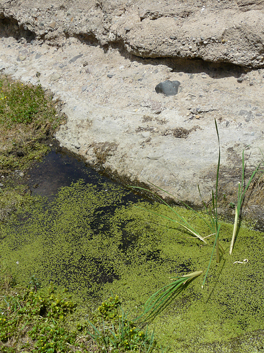
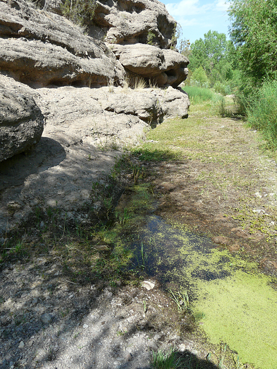
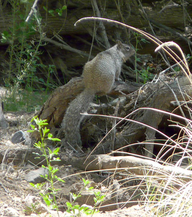
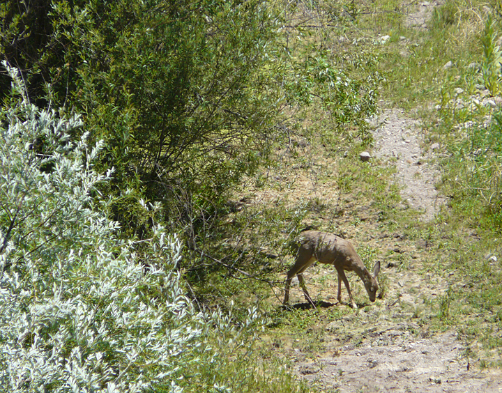
At the downstream border of the Casita lands there are low cliffs of Gila Conglomerate that extend down to the water’s edge on the west side of Bear Creek. Cut by sediment-laden flood waters over hundreds of thousands of years, these cliffs form ledges a few feet above the Creek and afford a perfect spot to study the varied types of volcanic rock that make up the conglomerate, and to observe the activity in the shallow pools that are perennially found here during the dry months of May and June. This morning found the pools present but greatly contracted, just a few inches deep. Here and there across the drying creek bed a few Broad-leaved Cattails had sprouted up. Most of these succulent cattail shoots, as evidenced by the countless foot prints in the area, had been chewed down to creek bed level by the small band of four to six Mule Deer that had been coming down to the Creek on a daily basis from the surrounding hills in the early morning and evening to drink and forage.
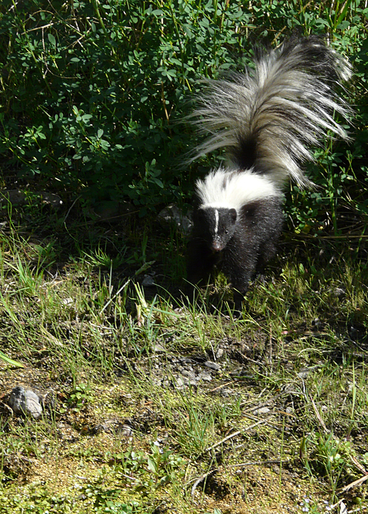
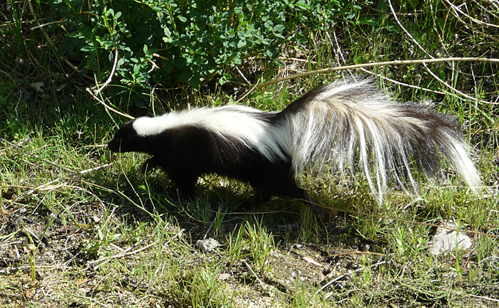
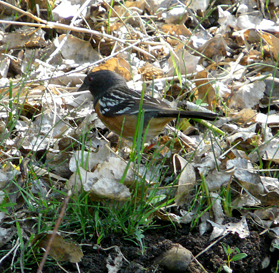
A hundred feet or so upstream from these lower cliffs, the channel of the Creek turns due east for about a thousand feet, passing beneath a dense growth of mature willow and young cottonwoods that overhang and shade the creek. This is a favorite haunt of all types of birds, animals, and creek dwellers, and this morning was no exception, as one paused to watch the Spotted Towhee scratching for insects in the dead cottonwood leaves at the edge of willow-shaded Watercress– and Duckweed-covered pools (the species found here being the Pale Duckweed), and the totally oblivious-to-one’s-motionless-presence-until-it-almost-tripped-over-one’s-feet Striped Skunk hunting for breakfast at the water’s edge!
Continuing upstream, one soon encounters the high sheer cliffs so readily seen across from the Casitas on the east side of the Creek, the same cliffs that comprise the safe haven refuge for the Bighorn Sheep when they are in the area. These cliffs consist of two sections: a short downstream section that faces north, and a much longer upstream section that faces west. Dividing the two sections at the exact point where the downstream course of the Creek changes from north-south to east-west is a steep, narrow cleft, eroded into the cliffside walls over thousands of years by sediment-laden storm runoff cascading down from the mountains above. This cleft serves as a much-used up-down passageway for numerous animals in the area, providing a protective, hidden pathway for the sheep in their stealthy descent from their aerie sanctuary above to the creek below, as well as providing an access route for other animals unable to scale the near vertical cliffs on either side.

Bear Creek flows tight up against the cliff face on both sides of the cleft, and it is here that the deepest pools are generally found during the dry times. This is due to the extreme turbulence and high-energy scouring of the creek bed that takes place here when the fast moving flood waters along the cliff face are forced to make a nearly right angle turn as the course of the creek changes from a southerly to westerly flow.
Although the sheep had moved on several days ago, signs of their last visit were obvious everywhere around the pools at the base of the cleft in the cliffs: cloven hoof prints by the hundreds, small mounds of distinctive pellet-shaped scat, and grasses and other creekside vegetation recently nibbled to the ground.
If one looks closely at this small stretch of the creek, with its dependable, deeper pools and protective cliffs above, it is obvious that it is a special gathering place for other inhabitants of Bear Creek Canyon as well. Looking up at the cliff faces, numerous crevices and horizontal recesses of various dimensions can be seen at different levels above the creek bed. High up, virtually inaccessible from the ground, large open nests of sticks and dried vegetation can be seen that are constructed and used by Chihuahua Ravens year after year. In other places, larger sticks and debris are piled into conspicuous mounds within shallow recesses on wide ledges with no apparent entrance visible, most likely the home of the Gray Fox.
Looking closer, one also observes numerous smaller crevices that extend back into the cliff, some of which appear to have been blocked off purposefully with bits of organic material and rock. It’s obvious that these conglomerate cliffs towering above Bear Creek are home to creatures of all types and sizes, mammals, reptiles, and insects, essentially serving as Nature’s high-rise condominiums in stone!
A hundred feet or so upstream from the cleft in the cliffs the creek bed diverges away from the cliffs and ascends a long, straight and narrow boulder-strewn channel running between dense growths of young Freemont Cottonwood, several species of willow and Arizona sycamore lining the banks on either side. In times of normal to high water levels, this section of the creek is characterized by a high-energy turbulent flow over a steeper gradient that leads to active downcutting of the channel and adjacent creek banks, plus selective removal of finer-grained sediments from the stream bed itself. The predominance of course sand to boulders, abundant concentrations of heavy mineral sands or “black sands” (high specific gravity minerals), coupled with an obvious steepening of the stream bed gradient suggests that the Gila Conglomerate bedrock is close to the surface along this section of the creek bed.
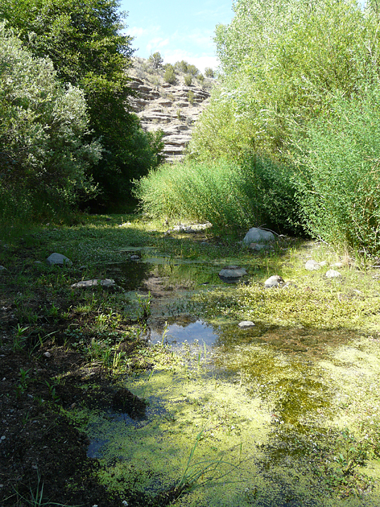
Today, however, the water level in this section is very low with only a few deeper pools and large boulders protruding from the creek bed as evidence of the higher energy flow that is found here during higher water levels. The weedy vegetation covering the banks of this section of the creek is thick, lush and now matured to the stage of flowering. The profusion of weeds along the banks is obviously enhanced by the amount of shade afforded by the tall cottonwoods and cliffs lining the creek, plus the continued presence of abundant water.

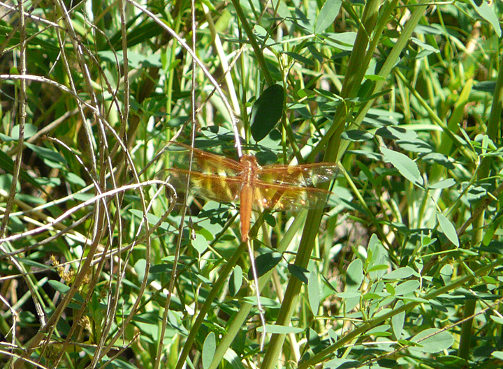
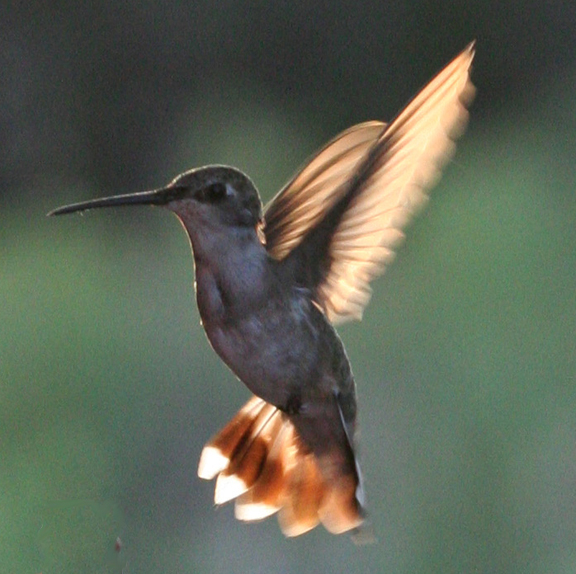
On this morning, the airspace above the channel is alive with the buzz and whir of flying insects of every type, from near-microscopic gnats, to pollen-coated honey bees and grey and white flitting butterflies in search of their favorite nectar, to small blue-bodied damselflies and large bright-orange dragonflies constantly patrolling up and down the creek bed, voraciously feeding on their smaller winged prey. Sitting quietly on the creek bank one is soon mesmerized by the primal spectacle of this lilliputian food-chain dance of Nature. Suddenly, the reverie is broken as one’s focus is drawn upward, startled by the rhythmic a-rumm, a-rumm, a-rumm zooming sound produced from a tiny Broad-tailed Hummingbird‘s alternating dives and ascents, engaged a little-known aerial stratagem, known only to the most dedicated avian devotees as “hover-hawking”, as it selectively gorges on the smorgasbord of insect prey below.
FLOODS: PRIMARY AGENT FOR PHYSICAL AND BIOLOGICAL CHANGE IN THE HIGH DESERT SOUTHWEST
Change in the physical and biological landscape of the High Desert Country of the American Southwest is immeasurably slow and unrecognizable by human standards most of the time. Weeks, months, and in some cases years can go by without noticeable visual change. Then, often in the matter of just a few hours, greater change can take place than has occurred in the past several previous decades. The primary agent of this change, of course, is running water, that eternally rare and unpredictable phenomenon of the American Southwest that turns flat desert landscapes into temporary lakes called playas, and gentle slopes, sandy dry washes or small creeks into raging torrents of mud and debris charged water called flash floods ravaging everything in their path. Unless one has personally witnessed such an event, the prime importance of running water upon the High Desert landscape is typically not appreciated or understood. However, it is in the floodplains of the creeks and rivers of the desert that one has the best opportunity for to observe and decipher the effects of running water upon this otherwise stoic and inscrutable landscape. Over the last 15 years here at the Casitas, Bear Creek has experienced one major flood and numerous small flash floods that have left behind an excellent observable record of the affects of running water upon this High Desert landscape. The final section of our morning’s nature walk up Bear Creek displays an excellent record of these high water events.
Continuing a few hundred feet more upstream from our “hover hawking” hummingbirds and dragonflies and past the end of the cliffs on the east side of the creek, the overall nature of the creek changes abruptly. The main channel is now found to be running along the west side of a broad floodplain that gradually widens in front of the Casitas to twice and then three times the width of the floodplain observed in front of the cliffs. East of the channel the broad floodplain is covered with a dense riverine forest of young cottonwood, willow, and sycamore, with some individual cottonwoods already reaching heights of 60 to 80 feet. This riverine forest provides a diverse habitat for a variety of birds, mammals, reptiles and amphibians who live here as well as visit regularly from the surrounding hills and mountain slopes. Many of these species are commonly observed by Casita guests during a quiet early morning or late afternoon nature excursion along the several maintained trails that traverse the floodplain.
Having observed the changes in this section of the floodplain for the past 15 years, it’s hard to believe that most of this dense forest is only 8 years old, with most of the young trees having grown up since the last major flood on Bear Creek in February 2005.
The 2005 flood resulted from a three-day precipitation event, in which a warm front coming up from Mexico dropped 2-1/2 inches of rain over the entire Bear Creek drainage, while simultaneously melting most of that winter’s snow pack in the mountains. The resulting high water on Bear Creek lasted for two weeks, and at its peak covered the entire floodplain bank to bank with waters up to 8 feet deep that swept downstream at speeds sometimes in excess of 20 miles an hour.
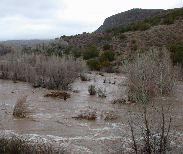
When the waters finally receded, it was seen that the main channel, which previously had been located along the base of the mountain across from the Casitas on the east edge of the floodplain, was now relocated 500 feet to the west on the opposite border of the floodplain up against the cliffs below the Casitas. Even more impressive were the changes in the floodplain itself. Not only had the floodwaters scoured away much of the vegetation covering the floodplain as the channel migrated to the opposite side of the canyon, but simultaneously, as the channel was migrating to the west, a backfilling process had occurred whereby the scoured floodplain was subsequently covered over with thick new layers of sand and gravel, leaving the surface across the new floodplain elevated by some four to five feet!
The changes just described in the Bear Creek floodplain that resulted from the 2005 flood are typical of any stream or watercourse not confined in solid rock, where the valley or canyon is wide enough, and the gradient low enough to permit the migration of the main channel in response to the changing energy of the stream, be it a small brook, creek, or large river system. Such streams are called meandering streams.
The Bear Creek flood of 2005 was an uncommon event for this area, and one that resulted from a unique combination of climatic events. Much more common are the small to medium-sized floods that occur each year during the summer Monsoon season, where intense thunderstorms, typically of short duration, will dump anywhere from an inch to three inches or more in rain over various parts of the Bear Creek drainage, resulting in flash floods. These floods will move downstream at speeds of 10 to 20 miles an hour, often arriving as a wall of water a few inches to several feet in height that will raise the water level for one to several hours. Flash floods can be very destructive because of the high percentage of sediment and debris that is being carried. However, because of their short duration they do not usually result in the large scale changes in the floodplain as occurred during the 2005 flood. Occasionally during the Monsoon Season, however, conditions will result in numerous intense thunderstorm activity being concentrated in a localized area for an extended period of time. While not common, the results can be disastrous in which the floodplain of a creek or river can undergo monumental change that will endure for decades.
On the east side of the floodplain across from the northernmost Casita, there are several mature growth cottonwoods that are situated on an old stream terrace about 7 to 10 feet above the present floodplain. These trees are very old, with the largest one measuring some 27 feet in circumference. Dating of old cottonwoods and sycamores in the floodplain is difficult, but the age of this tree is estimated to be in excess of 200 years. The tree is growing against a cliff face of Gila Conglomerate which clearly has protected it from severe wind storms, lightning, and rampaging floods down through the years. Undoubtedly this tree has witnessed floods in the past which would dwarf the 2005 flood in terms of floodplain change. Oh, what stories this tree could tell if we mortals could only hear!
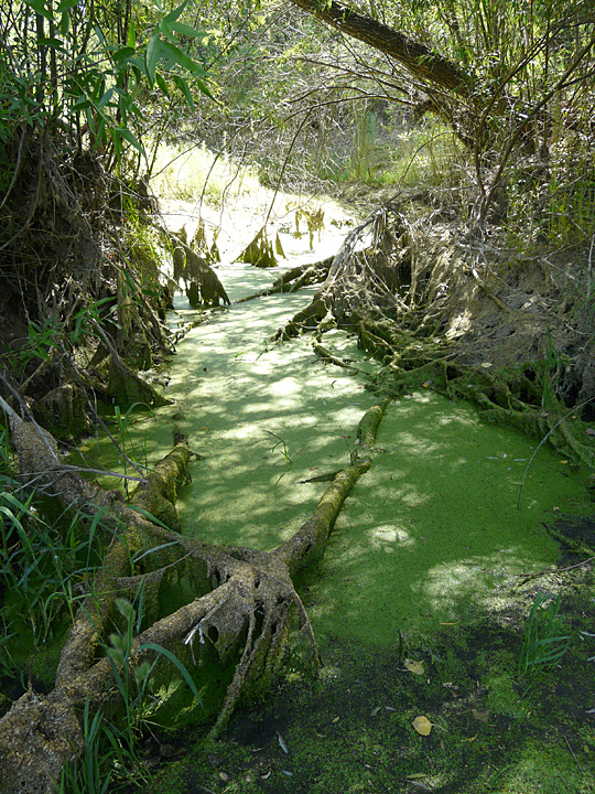
It is a few feet in front of this giant cottonwood that we end our nature excursion, at the side of a small, but quite deep pool that was scoured out by high-energy flood waters during a substantial summer monsoon a few years ago. Approaching the pool, one notices that the water level in the pool has dropped more than a foot to expose numerous roots and fallen branches that are now draped in drying duckweed and watercress. Several splash and kerplunk sounds are heard as one draws closer to see that the pool, still at least a foot deep, is completely covered over with duckweed, that is, all except for one pair of protruding, large and knobby, green-rimmed black eyes.
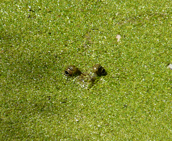
an American Bullfrog hiding!
